Filter: Categories of Wisconsin Historical Images
Filter: Subject of Rivers
Filter: County of Wood
Filter: Categories of Wisconsin Historical Images
Filter: Subject of Rivers
Filter: County of Wood

| Date: | 1951 |
|---|---|
| Description: | Aerial view of the Nekoosa-Edwards Paper Company nursery. |

| Date: | 1874 |
|---|---|
| Description: | Bird's-eye map of Grand Rapids. |
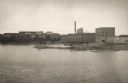
| Date: | 1900 |
|---|---|
| Description: | View of river and the building's exterior. This building is where Consolidated Water Power and Paper company operates its business. The building's facad... |
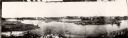
| Date: | 1885 |
|---|---|
| Description: | A panoramic view of the east bank of the Wisconsin River from the Green Bay & Western Railway bridge to the wagon bridge. |
| Date: | 1920 |
|---|---|
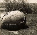
| Description: | The inscription on the rock reads: "Ah-Dah-Wa-Gam Chapter D.A.R. In recognition of the Loyalty & Patriotism of the Winnebago Indians." "General Foster Deco... |
| Date: | 10 26 1986 |
|---|---|
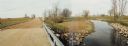
| Description: | Green Elm Road Bridge over the east fork of Hemlock Creek, showing the rocks used to prevent erosion. |
| Date: | 06 06 1981 |
|---|---|
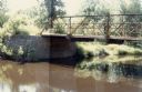
| Description: | Panoramic view of the north side of the old bridge over Rocky Run in the Town of Hiles, Wood County, Wisconsin. |
| Date: | 1925 |
|---|---|
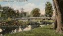
| Description: | View from shoreline towards a bridge in Gleason's Park. Caption reads: "Bridge at Gleason's Park, Marshfield, Wis." |
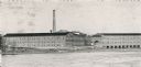
| Date: | 1900 |
|---|---|
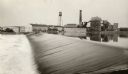
| Description: | Nekoosa-Edwards Paper Company, Nekoosa Mill. Operated by water power to produce news and book paper from both ground wood and sulphite pulp on two wide pap... |

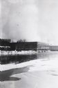
| Date: | 1964 |
|---|---|
| Description: | Marshfield Airways, covered with snow. A river full of ice and snow, with boats along the shoreline, is in the lower portion of the image. |

| Date: | 1892 |
|---|---|
| Description: | 1 map on 4 sheets : col., mounted on cloth ; Shows landownership, roads and railroads, townships, and selected buildings. Includes "Professional directory... |

| Date: | 1913 |
|---|---|
| Description: | View from shoreline towards a stone pedestrian bridge on a river. The city skyline is in the distance. Caption reads: "Strollers Bridge, Grand Rapids, Wis.... |

| Date: | 03 1978 |
|---|---|
| Description: | Elevated view of Tenmile Creek in the winter. There is ice and snow along the side of the creek. |

| Date: | 03 1978 |
|---|---|
| Description: | Elevated view of Tenmile Creek as it runs parallel to a road. |

| Date: | 08 12 1915 |
|---|---|
| Description: | Text on front reads: "Dam, Vesper, Wis." The privately owned dam was built on the Hemlock Creek River in 1944 for recreational purposes. Buildings are beyo... |
If you didn't find the material you searched for, our Library Reference Staff can help.
Call our reference desk at 608-264-6535 or email us at: