 Filter: Categories of Wisconsin Historical Images
Filter: Subject of Rivers
Filter: County of Waukesha
Filter: Categories of Wisconsin Historical Images
Filter: Subject of Rivers
Filter: County of Waukesha

| Date: | 1885 |
|---|---|
| Description: | Bird's-eye map of Oconomowoc. |

| Date: | 1886 |
|---|---|
| Description: | Bird's-eye map of Menomonee Falls. |

| Date: | 1857 |
|---|---|
| Description: | Elevated view of Waukesha with two women wearing dresses with a boy in long pants and tam o'shanter hat in foreground against a split-rail fence. Beyond th... |

| Date: | 1880 |
|---|---|
| Description: | Bird's-eye map of Waukesha, county seat of Waukesha County. |

| Date: | 1874 |
|---|---|
| Description: | Bird's-eye view of Waukesha, looking southwest, with insets of State Industrial School, Court House, and Fountain Spring House. |

| Date: | |
|---|---|
| Description: | View of the tree-lined Fox River, with a bridge in the distance. Caption reads: "Fox River, Waukesha, Wis." |
| Date: | 1920 |
|---|---|
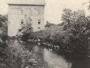
| Description: | Nagowicka Roller Mills and mill race on river. Ducks are entering the water. |
| Date: | 1876 |
|---|---|
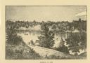
| Description: | Distant view of Neshotah Mission. River with boaters, two people standing on riverbank, mission on hill in background. |
| Date: | 1911 |
|---|---|
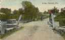
| Description: | Man and dog standing near bridge. Buildings in background. There is a boat on the left on the water near the bridge. Caption reads: "Bridge, Okauchee, Wis.... |

| Date: | 1851 |
|---|---|
| Description: | Map of a portion of Merton including the Bark River, a mill, Fort Hill, and Indian mounds. |
| Date: | 04 09 1935 |
|---|---|
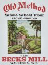
| Description: | Label submitted to the State of Wisconsin for trademark registration. Features an illustration of a mill on a river. "Old Method, Whole Wheat Flour, Stone ... |

| Date: | 11 14 1942 |
|---|---|
| Description: | This pictorial map illustrates Potawatomi Indian legends from the region of Lower Phantom Lake, labeled Howitt Lake on the map, Phantom Lake, and Mukwonag... |

| Date: | 1896 |
|---|---|
| Description: | Map shows landownership and acreages, roads, and townships. |

| Date: | 1898 |
|---|---|
| Description: | Map showing the contour depths of the lakes in northwestern Waukesha County, Wisconsin. Roads, railroads, depots, churches, schools, and hotels in the area... |

| Date: | 03 29 1888 |
|---|---|
| Description: | "Dated this 29th day of March AD 1888." Certifications on verso signed by: William Powrie, county surveyor -- Henry Sherry, landowner -- E.E. Paddock, not... |

| Date: | 1873 |
|---|---|
| Description: | Plat map of the township of Eagle (T5N, R17E) at a scale of 2 inches to one mile. |

| Date: | 1846 |
|---|---|
| Description: | This map of Prairieville, later renamed Waukesha, is ink and pencil on paper and shows the Fox River, a plat of village, and lot owners. |

| Date: | 1871 |
|---|---|
| Description: | This map of Waukesha shows lot owners, buildings, and various plat additions. The margins of the maps include street reference, a Waukesha business directo... |

| Date: | 1954 |
|---|---|
| Description: | This map of Waukesha shows numbered ward boundaries, roads, and some buildings. The bottom of the map includes a street index. |
If you didn't find the material you searched for, our Library Reference Staff can help.
Call our reference desk at 608-264-6535 or email us at:
