 Filter: Categories of Wisconsin Historical Images
Filter: Subject of Rivers
Filter: County of Vilas
Filter: Subject of rivers
Filter: Categories of Wisconsin Historical Images
Filter: Subject of Rivers
Filter: County of Vilas
Filter: Subject of rivers
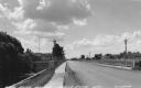
| Date: | 1945 |
|---|---|
| Description: | View towards the Eagle River bridge. Caption reads: "Eagle River Bridge, Eagle River, Wis." |

| Date: | 1923 |
|---|---|
| Description: | Vilas County. Published by Chicago, Milwaukee, and St. Paul Ry. |

| Date: | 07 1974 |
|---|---|
| Description: | Nelson takes time out during a campaign trip to talk with two boys. Dressed casually, Nelson is shown squatting down in a marsh area between the boys who a... |
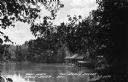
| Date: | |
|---|---|
| Description: | View along shoreline through trees of a wet boathouse at The Morey Resort. Caption reads: "Boat House, The Morey Resort, Eagle River, Wis." |

| Date: | 1933 |
|---|---|
| Description: | This 1933 Wisconsin Conservation Dept. map shows roads, railroads, trails, lakes and streams, and the Trout Lake Game Refuge in Northern State Forest (whic... |

| Date: | 1875 |
|---|---|
| Description: | This manuscript map by Increase Lapham, drawn in the last year of his life, shows landownership, roads and railroads, springs, and boat houses around Ocono... |

| Date: | 1908 |
|---|---|
| Description: | This 1908 map shows the town and range grid, sections, cities and villages, acreages, settlers, schools, wagon roads, railroads, saw mills, and lakes, stre... |

| Date: | 1952 |
|---|---|
| Description: | This Wisconsin Conservation Dept. map shows sections, roads, rivers, and lakes in the Town of Cloverland, Vilas County, Wisconsin as of February, 1952. It ... |

| Date: | 1952 |
|---|---|
| Description: | This Wisconsin Conservation Dept. map shows sections, roads, rivers, and lakes in the Town of Presque Isle, Vilas County, Wisconsin as of March 1953. It do... |

| Date: | 1910 |
|---|---|
| Description: | Elevated view of the Eagle River dock, with excursion boats and a tug boat alongside two long piers in the foreground, and a steel frame bridge in the back... |

| Date: | 1910 |
|---|---|
| Description: | View from shoreline of the Wagon Bridge, which has a steel frame and stone piers. Possibly on Railroad Street. Caption reads: "Wagon Bridge over Eagle Rive... |

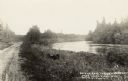
| Date: | 1910 |
|---|---|
| Description: | View from pier of two boys in a rowboat in the river, east of Eagle River. Caption reads: "Thoroughfare Between Cranberry & Catfish Lakes, Eagle River, Wis... |
| Date: | 1905 |
|---|---|
| Description: | The unpaved road along a river on the way to the Red Oak Resort. Caption reads: "On The Road to Red Oaks Resort, Near Eagle River, Wis." |

| Date: | 1935 |
|---|---|
| Description: | This map shows railroads, telephone lines, roads, trails, schools, sub-agency, lookout stations, churches, community centers, and school site and farm. Bil... |

| Date: | 1962 |
|---|---|
| Description: | This map shows roads, golf courses, ski areas, boat landings, camp sites, waysides, parks, beaches, scenic views, virgin timber tracts, airports, boys and ... |

| Date: | 1955 |
|---|---|
| Description: | This map shows roads, golf courses, airports, fire towers, schools, camp grounds, rivers, streams, lakes, and railroads. The right margin of the map includ... |

| Date: | 1975 |
|---|---|
| Description: | This map shows nature trails, public attractions, public hunting and fishing grounds, dams, waysides, lakes, highways, and roads. The upper right corner in... |

| Date: | 1994 |
|---|---|
| Description: | This map shows historical sites, picnic grounds, public boat landings, canoe and motor boat trips, and resort locations. The left margin of the map include... |

| Date: | |
|---|---|
| Description: | View of the village of Lac du Flambeau from across a river. Caption reads: "Lac du Flambeau, Wis." |
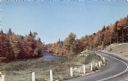
| Date: | |
|---|---|
| Description: | Photographic postcard view of winding road along a river, with trees in fall color. |
If you didn't find the material you searched for, our Library Reference Staff can help.
Call our reference desk at 608-264-6535 or email us at: