 Filter: Categories of Wisconsin Historical Images
Filter: Subject of Rivers
Filter: County of Vilas
Filter: Creator Name of Unknown
Filter: Categories of Wisconsin Historical Images
Filter: Subject of Rivers
Filter: County of Vilas
Filter: Creator Name of Unknown

| Date: | 1923 |
|---|---|
| Description: | Vilas County. Published by Chicago, Milwaukee, and St. Paul Ry. |
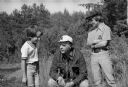
| Date: | 07 1974 |
|---|---|
| Description: | Nelson takes time out during a campaign trip to talk with two boys. Dressed casually, Nelson is shown squatting down in a marsh area between the boys who a... |

| Date: | 1910 |
|---|---|
| Description: | Elevated view of the Eagle River dock, with excursion boats and a tug boat alongside two long piers in the foreground, and a steel frame bridge in the back... |

| Date: | 1955 |
|---|---|
| Description: | This map shows roads, golf courses, airports, fire towers, schools, camp grounds, rivers, streams, lakes, and railroads. The right margin of the map includ... |

| Date: | 1975 |
|---|---|
| Description: | This map shows nature trails, public attractions, public hunting and fishing grounds, dams, waysides, lakes, highways, and roads. The upper right corner in... |

| Date: | |
|---|---|
| Description: | View of the village of Lac du Flambeau from across a river. Caption reads: "Lac du Flambeau, Wis." |
If you didn't find the material you searched for, our Library Reference Staff can help.
Call our reference desk at 608-264-6535 or email us at: