 Filter: Categories of Wisconsin Historical Images
Filter: Subject of Rivers
Filter: County of Taylor
Filter: Categories of Wisconsin Historical Images
Filter: Subject of Rivers
Filter: County of Taylor
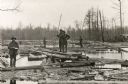
| Date: | 1910 |
|---|---|
| Description: | Logging crew standing on planks and logs possibly in a sorting works on the Yellow River. One man holds a ledger and the others hold long cant hooks. |

| Date: | 1960 |
|---|---|
| Description: | This manuscript map of Taylor County, Wisconsin, shows the township and range grid, lakes and streams, "Chippewa trails, Indian trails" Indian villages and... |

| Date: | 1930 |
|---|---|
| Description: | This map shows communities, state roads, county roads, railroads, lakes and rivers in the county. Areas marked in red are lands tax deeded to the county. |
If you didn't find the material you searched for, our Library Reference Staff can help.
Call our reference desk at 608-264-6535 or email us at:
