 Filter: Categories of Wisconsin Historical Images
Filter: Subject of Rivers
Filter: County of Sheboygan
Filter: Year of 1800-1899
Filter: Categories of Wisconsin Historical Images
Filter: Subject of Rivers
Filter: County of Sheboygan
Filter: Year of 1800-1899

| Date: | 1885 |
|---|---|
| Description: | Bird's-eye view of Sheboygan, with inset of J.J. Volrath Manufacturing Company. |
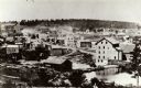
| Date: | 1868 |
|---|---|
| Description: | A view taken from the elevation on the south side of the Mullet River. |

| Date: | 1857 |
|---|---|
| Description: | This map of Sheboygan Harbor shows the river mouth and harbor, piers, wharfs, piles of old destroyed bridge wharfs, streets, and the lake shore from survey... |

| Date: | 1836 |
|---|---|
| Description: | This 1836 map consists chiefly of a detailed map of the the mouth of the Sheboygan River. An inset map of the region and cross section diagrams of the pier... |

| Date: | 1840 |
|---|---|
| Description: | This is a plat map of Sheboygan showing the Sheboygan River and Lake Michigan. Streets are labeled and plats are numbered in quadrants. Some points of inte... |

| Date: | 1893 |
|---|---|
| Description: | This map shows wards, railroads, street cars, streets, lot and block numbers, landownership, parks, hospitals, the Sheboygan River, and Lake Michigan. Ward... |
If you didn't find the material you searched for, our Library Reference Staff can help.
Call our reference desk at 608-264-6535 or email us at:

