Filter: Categories of Wisconsin Historical Images
Filter: Subject of Rivers
Filter: County of Sawyer
Filter: Categories of Wisconsin Historical Images
Filter: Subject of Rivers
Filter: County of Sawyer
| Date: | 1910 |
|---|---|
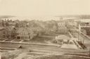
| Description: | Elevated view of various buildings with Sturgeon Bay in the background. |
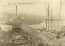
| Date: | 05 05 1911 |
|---|---|
| Description: | Elevated view of construction on Arpin's dam. Men are working on the right. Caption reads: "Arpin's Dam at Radisson, Wis". |

| Date: | 1919 |
|---|---|
| Description: | This is a collection of three hand-colored plat maps. One map is a plat plan and includes annotations and an index that shows public land, business, indust... |
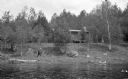
| Date: | |
|---|---|
| Description: | View from water of a man wearing a hat and boots walking along the shoreline. A cabin is located up on the bank. |
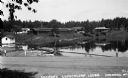
| Date: | 1935 |
|---|---|
| Description: | Variety of buildings reflected in Teal Lake. A wooden rowboat is tied to a pier on the lake. The Teal River is rushing over a nearby dam and along the dirt... |
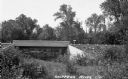
| Date: | 1935 |
|---|---|
| Description: | View from side of river of cement bridge over the Chippewa River in Sawyer County, possibly on County Highway B. |

| Date: | 1898 |
|---|---|
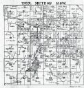
| Description: | This 1898 map of Sawyer County, Wisconsin, shows the township and range system, sections, roads, farm houses, camps, school houses, dams, bridges, Indian r... |

| Date: | 1900 |
|---|---|
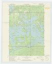
| Description: | This map of Sawyer County, Wisconsin, shows the numbered "sub-school-districts of the town of Hayward" school houses, and the Indian reservation. The towns... |

| Date: | 1970 |
|---|---|
| Description: | This map shows lot and block numbers, city limits, cemeteries, schools, outdoor theater, Lumberjack Bowl, and Historyland among other attractions. |

| Date: | 1911 |
|---|---|
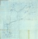
| Description: | This map shows lakes, rivers, swamps, state swamp land, trails and railroads. Includes a township diagram. |

| Date: | |
|---|---|
| Description: | Two men are log rolling on the Namakagon River at the North Wisconsin Logging Camp and Museum. Rowboats are moored next to a dock. |
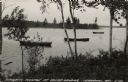
| Date: | 1948 |
|---|---|
| Description: | View of the flowage of the Totogatic, a designated wild river. Three rowboats are anchored just off shore. |
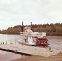
| Date: | |
|---|---|
| Description: | Men, women, and children are on a riverboat named "Namekagon Queen," which is on the Namekagon River next to a wooden dock. |
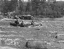
| Date: | 09 1930 |
|---|---|
| Description: | View across river towards three men in a canoe negotiating the Cedar Rapids of the Flambeau. Large boulders are along the far shoreline. On the reverse of ... |

| Date: | 1946 |
|---|---|
| Description: | Two canoes are pulled up on the shoreline in the Flambeau River State Forest. |
If you didn't find the material you searched for, our Library Reference Staff can help.
Call our reference desk at 608-264-6535 or email us at: