Filter: Categories of Wisconsin Historical Images
Filter: Subject of Rivers
Filter: County of Sauk
Filter: Subject of transportation
Filter: Categories of Wisconsin Historical Images
Filter: Subject of Rivers
Filter: County of Sauk
Filter: Subject of transportation

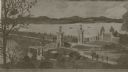
| Date: | 1870 |
|---|---|
| Description: | Baraboo was first settled around 1838, and by 1870 it had become the county seat and the thriving village illustrated here. This birds eye drawing depicts ... |
| Date: | 1876 |
|---|---|
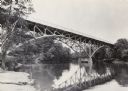
| Description: | View, from the north bank of the Wisconsin River, of the 1899-foot railroad bridge in Merrimac. Two women and a man are sitting on the riverbank in the for... |
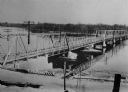
| Date: | 1873 |
|---|---|
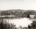
| Description: | View, from the south bank of the Wisconsin River, looking towards Merrimac, Sauk County. People are standing on the 1899-foot railroad bridge, which runs ... |
| Date: | |
|---|---|
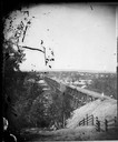
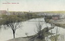
| Description: | Elevated view of the Baraboo River towards a bridge, water tower, and the town beyond. Caption reads: "Baraboo River, Baraboo, Wis." |
| Date: | 1914 |
|---|---|
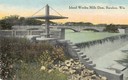
| Description: | Slightly elevated view of the dam, with a bridge in the background. Caption reads: "Island Wollen Mills Dam, Baraboo, Wis." |
| Date: | 1918 |
|---|---|
| Description: | View of the Ringling Brothers Circus winter quarters from across the Baraboo River, looking due north. The brick building, center, was one of the two "Cat ... |
| Date: | 1918 |
|---|---|
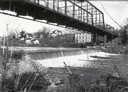
| Description: | View of waterfall, bridge, Baraboo river, and town from the riverbank. |

| Date: | 1950 |
|---|---|
| Description: | Map showing buildings formerly used as Ringling Brothers Circus winter quarters, along with adjoining buildings. |
| Date: | 1940 |
|---|---|
| Description: | View of town from the south, with the Baraboo River on the other side of the road. |
| Date: | 1920 |
|---|---|
| Description: | View of the Wisconsin River Bridge in the vicinity of Spring Green. |

| Date: | 1859 |
|---|---|
| Description: | Map featuring various views of buildings and scenes from Sauk County. |
| Date: | 1922 |
|---|---|
| Description: | View of the approach to the Wisconsin River bridge. |
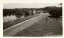
| Date: | 1925 |
|---|---|
| Description: | Elevated view of dam and power station on a river. Two automobiles are parked in a lot in the lower left corner. Bluffs are in the distance. |
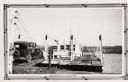
| Date: | 1940 |
|---|---|
| Description: | Colsac Ferry across the Wisconsin River at Merrimac. There is a bridge across the river in the background on the left. |
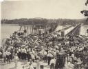
| Date: | 1920 |
|---|---|
| Description: | Crowd gathered for the dedication of a new bridge at Sauk City by Governor Emmanuel Philipp. Many onlookers carry parasols. |
| Date: | 1900 |
|---|---|
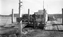
| Description: | Car boarding the ferry on left side. The far shoreline can be seen in the background. |
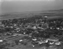
| Date: | 04 21 1949 |
|---|---|
| Description: | Aerial view of Spring Green. Houses and commercial buildings are in the foreground and a rural area is in the background. Hills are in the distance. |
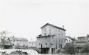
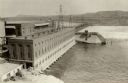
| Date: | 1924 |
|---|---|
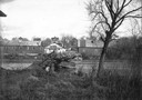
| Description: | The dam and four-story wooden mill on the Baraboo River. A bridge crosses the river on the left. There are houses and commercial buildings in the backgrou... |
If you didn't find the material you searched for, our Library Reference Staff can help.
Call our reference desk at 608-264-6535 or email us at: