 Filter: Categories of Wisconsin Historical Images
Filter: Subject of Rivers
Filter: County of Price
Filter: Creator Name of Unknown
Filter: Categories of Wisconsin Historical Images
Filter: Subject of Rivers
Filter: County of Price
Filter: Creator Name of Unknown

| Date: | 1910 |
|---|---|
| Description: | This map is ink on paper. Shows Bruce’s proposed railway route and Moon’s railroad survey route along the Flambeau River, in parts of Lake and Eisenstein t... |
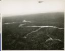
| Date: | 01 1934 |
|---|---|
| Description: | Aerial view of a forest with a river running through it. |

| Date: | 1903 |
|---|---|
| Description: | This blue line print map is oriented with the north to the left and shows buildings with dimensions, utilities, and proposed buildings. The Flambeau River ... |
If you didn't find the material you searched for, our Library Reference Staff can help.
Call our reference desk at 608-264-6535 or email us at: