 Filter: Categories of Wisconsin Historical Images
Filter: Subject of Rivers
Filter: County of Pepin
Filter: Categories of Wisconsin Historical Images
Filter: Subject of Rivers
Filter: County of Pepin
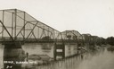
| Date: | 1911 |
|---|---|
| Description: | View towards the bridge along the left. Trees are along the opposite shoreline. Caption reads: "Bridge, Durand Wis." |
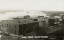
| Date: | 1910 |
|---|---|
| Description: | Elevated view of commercial buildings along the river from the vantage point of the Court House. Horse-drawn carriages and pedestrians are along the street... |
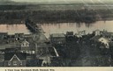
| Date: | 1900 |
|---|---|
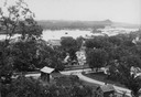
| Description: | Elevated view of Durand. A street in the foreground leads to a bridge that crosses the river. Caption reads: "A View from Morsbach Bluff, Durand, Wis." |
| Date: | 1910 |
|---|---|
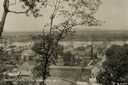
| Description: | Elevated view of Durand from a high vantage point, looking towards the river. A bridge spans the river, and in the foreground just below the hill is a chur... |
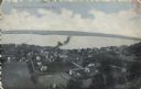
| Date: | 1910 |
|---|---|
| Description: | Elevated view from hill of Durand through trees, with houses in the foreground, and the river and hills in the background. Taken in the summer, with wash o... |
| Date: | |
|---|---|
| Description: | View from hill looking down at houses and buildings at an intersection. Beyond are commercial buildings, the river, and the far shoreline. Hills are in the... |

| Date: | 1887 |
|---|---|
| Description: | This 1887 manuscript map by Amidon G. Miller covers portions of the towns of Nelson and Stockholm in Pepin County, Wisconsin, as well as a portion of the T... |

| Date: | 1913 |
|---|---|
| Description: | This 1913 map of Pepin County, Wisconsin, shows the township and range grid, towns, villages, rural routes, railroads, roads, schools, churches, cemeteries... |

| Date: | 1922 |
|---|---|
| Description: | This map of Pepin County, Wisconsin, from the first half of the 20th century shows the township and range grid, towns, villages, railroads, roads, schools,... |
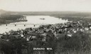
| Date: | 1910 |
|---|---|
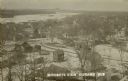
| Description: | Elevated view of the town with snow on the ground. Houses are near an intersection in the foreground, and homes and commercial buildings are along the shor... |
| Date: | 1910 |
|---|---|
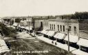
| Description: | Elevated view towards one side of Main Street, with the bridge over the Chippewa River in the background. Commercial buildings are along the sidewalk, and ... |

| Date: | 1920 |
|---|---|
| Description: | Photographic postcard view from shoreline of the truss bridge over the Chippewa River. Caption reads: "Chippewa River Bridge, Durand, Wis." |

| Date: | 1850 |
|---|---|
| Description: | This series of maps shows townships, ranges, sections, lakes, rivers, and roads. The maps cover areas between Township No. 26 and Township No. 42. |
| Date: | 05 19 1908 |
|---|---|
| Description: | Text on front reads: "Bird's-Eye View of Stockholm, Wis." A village in Pepin County, founded in 1854 by immigrants from Karlskoga, Sweden, who named it aft... |
If you didn't find the material you searched for, our Library Reference Staff can help.
Call our reference desk at 608-264-6535 or email us at: