 Filter: Categories of Wisconsin Historical Images
Filter: Subject of Rivers
Filter: County of Ozaukee
Filter: Categories of Wisconsin Historical Images
Filter: Subject of Rivers
Filter: County of Ozaukee
| Date: | |
|---|---|
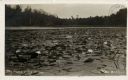
| Description: | View of water lilies and lily pads in a river. Caption reads: "The Home of the Muskie." |

| Date: | 06 1969 |
|---|---|
| Description: | The Cedarburg Bridge, originally known as the Red Bridge, with a flowering tree on the right. Originally Wisconsin had more than 40 covered bridges. This i... |

| Date: | 1921 |
|---|---|
| Description: | A plat map of Mequon, Wisconsin. Text at top reads: "T. 9N. R.21 E MEQUON T. 9N. R.22 E." |

| Date: | 1915 |
|---|---|
| Description: | A composite plat map of the towns of Mequon, Saukville, Belgium, Fort Washington, and Fredonia. |
If you didn't find the material you searched for, our Library Reference Staff can help.
Call our reference desk at 608-264-6535 or email us at:

