Filter: Categories of Wisconsin Historical Images
Filter: Subject of Rivers
Filter: County of Ozaukee
Filter: Categories of Wisconsin Historical Images
Filter: Subject of Rivers
Filter: County of Ozaukee
| Date: | 1940 |
|---|---|
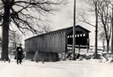
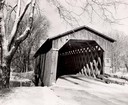
| Description: | Exterior view of the last covered bridge in Wisconsin. Caption reads: "Covered Bridge Near Cedarburg, Wis." |

| Date: | 1882 |
|---|---|
| Description: | This map of Cedarburg is a bird's-eye map with an inset of Cedarburg Brewery. Relief is shown pictorially and the map includes an index to buildings. |

| Date: | 2007 |
|---|---|
| Description: | This map of Cedarbug is a bird's-eye map with 8 inset views and an index. The map is a print out of the original map dated 1892 held at the Cedarburg Cultu... |
| Date: | |
|---|---|
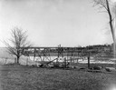
| Description: | View across field towards the railroad bridge, seen with the construction almost completed. A man is standing in the middle of the bridge, and two or three... |
| Date: | 1934 |
|---|---|
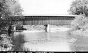
| Description: | Southwest view of a covered bridge over Cedar Creek, with a man walking in the snow nearby. |
| Date: | 1957 |
|---|---|
| Description: | Covered bridge over Cedar Creek in Ozaukee County on highway, about one mile north of Cedarburg. The last remaining covered bridge in Wisconsin. Snow is on... |
| Date: | 1950 |
|---|---|
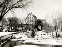
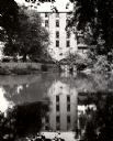
| Description: | The Thiensville Mill as seen from the waterfront. |
| Date: | 1952 |
|---|---|
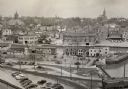
| Description: | An elevated view of the downtown section. |
| Date: | 1909 |
|---|---|
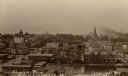
| Description: | Elevated view of town. Caption reads: "Birdseye View Port Washington, Wis." |
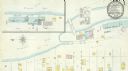
| Date: | 11 1894 |
|---|---|
| Description: | A detail of a Sanborn map of Grafton which includes the Milwaukee River. |
| Date: | |
|---|---|
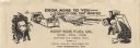
| Description: | Letterhead of the West Side Fuel Company of Port Washington, Wisconsin, with cartoon-style drawings, printed in black ink, of workers mining coal with a pi... |

| Date: | 1876 |
|---|---|
| Description: | This map shows existing and proposed harbor improvements, streets, the Sauk River, and Lake Michigan. On the bottom of the map inscribed in ink is: "44th C... |

| Date: | 1960 |
|---|---|
| Description: | This blue line print map shows zone districts, lot and block numbers and dimensions, building setbacks, center lines of streets, and some landownership. Th... |

| Date: | |
|---|---|
| Description: | Photographic postcard of a mill next to Cedar Creek. There is a bridge on the right, and a factory in the background.. |

| Date: | 1906 |
|---|---|
| Description: | Elevated view of the Cedarburg skyline from a bridge over Cedar Creek. There are dwellings in the foreground. Caption reads: "Looking North from Bridge, Ce... |

| Date: | |
|---|---|
| Description: | Photographic postcard view of the Woolen Mill Dam. Several dwellings are in the distance. Caption reads: "Woolen Mill Dam, Cedarburg, Wis." |

| Date: | |
|---|---|
| Description: | Tinted view of the Planing Mill, with Cedar Creek running alongside. There is a bridge on the left. Caption reads: "Planing Mill from Park Street, Cedarbur... |
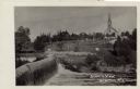
| Date: | 1918 |
|---|---|
| Description: | View of Grafton from across a dam on the Milwaukee River. St. Joseph's Catholic Church is in the distance on a hill. Caption reads: "Scenic View, Grafton, ... |
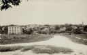
| Date: | 1916 |
|---|---|
| Description: | View of Grafton from the road leading into town. There is a bridge over the river, and a church is on the far right. Caption reads: "Birdseye [sic] View, G... |
If you didn't find the material you searched for, our Library Reference Staff can help.
Call our reference desk at 608-264-6535 or email us at: