Filter: Categories of Wisconsin Historical Images
Filter: Subject of Rivers
Filter: County of Monroe
Filter: Categories of Wisconsin Historical Images
Filter: Subject of Rivers
Filter: County of Monroe

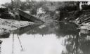
| Date: | 05 31 1965 |
|---|---|
| Description: | Elevated view of Evangelical United Brethren church in the vicinity of Highway T. |
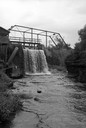
| Date: | 06 02 1943 |
|---|---|
| Description: | View from water of bridge collapsed into the river, with the metal supports half submerged and the brick base crumbling. Dwellings can be seen along the hi... |
| Date: | 1922 |
|---|---|
| Description: | A map of the Beaver Creek Valley in Monroe, Wisconsin along Beaver Creek and the La Crosse River, showing roads, railroads, and land ownership as well as p... |

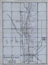
| Date: | 1903 |
|---|---|
| Description: | This map shows townships and sections, landownership and acreages, roads, railroads, and selected rural buildings. Townships and sections appear in yellow,... |
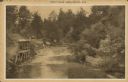
| Date: | 1929 |
|---|---|
| Description: | Text on front reads: "Trout Falls, Near Sparta, Wis." Elevated view of river. On the left bank at the base of the falls is an open-sided stilt structure wi... |
If you didn't find the material you searched for, our Library Reference Staff can help.
Call our reference desk at 608-264-6535 or email us at: