Filter: Categories of Wisconsin Historical Images
Filter: Subject of Rivers
Filter: County of Milwaukee
Filter: Categories of Wisconsin Historical Images
Filter: Subject of Rivers
Filter: County of Milwaukee
| Date: | |
|---|---|
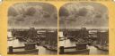
| Description: | Letterhead of the Milwaukee Willow Works, a manufacturer of children's carriages, willow ware, and toys, with a three-quarter view of the company building,... |

| Date: | |
|---|---|
| Description: | Memohead of the Plankinton Packing Company, a pork and beef packer and provision dealer in Milwaukee, Wisconsin. Includes an elevated view of the company b... |

| Date: | 1878 |
|---|---|
| Description: | This map shows block numbers, wards, roads, railroads, parks, and selected buildings and includes a "Milwaukee city street guide" as well as a guide to pub... |

| Date: | |
|---|---|
| Description: | Letterhead of the Phillip Best Brewing Company of Milwaukee, Wisconsin, with three separate proscenium views of the Empire Brewery, the South Side Brewery,... |
| Date: | |
|---|---|
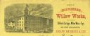
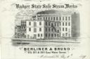
| Description: | Letterhead of the Berliner & Bruno's Badger State Safe Steam Works of Milwaukee, Wisconsin, with a three-quarter view of the steam works and depot, people ... |

| Date: | |
|---|---|
| Description: | Memohead of the Milwaukee Dry Dock Company, which operated two docks, with a view of a dock with ships, planks of wood, buildings, and the slogan, "Electri... |
| Date: | 1933 |
|---|---|
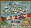
| Description: | Label submitted to the state of Wisconsin for trademark registration. "Blatz, Old Heidelberg Castle, Beer, Blatz Brewing Co." Pictured on the label is a sc... |

| Date: | 1836 |
|---|---|
| Description: | This hand-colored manuscript map shows the township and section grid in southeastern Wisconsin, covering the area west to Sugar River and Four Lakes region... |

| Date: | 05 1846 |
|---|---|
| Description: | Hand-colored map of southeastern Wisconsin showing the counties of Dodge, Jefferson, Rock, Walworth, Racine (including modern-day Kenosha County), Waukesha... |
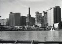
| Date: | 1938 |
|---|---|
| Description: | View across the Kinnickinnic River of the Pabst brewery grain elevator. A Schlitz building, possibly one of their grain elevators, stands behind the Pabst ... |

| Date: | |
|---|---|
| Description: | Stereograph elevated view from the dome of the Milwaukee Exposition Building looking south at the urban landscape. The cyclorama building in the foreground... |

| Date: | |
|---|---|
| Description: | Stereograph of two workers placing barrels of coal onto wheelbarrows to unload off a ship. Text at right: "Milwaukee and Vicinity, Photographed by H.H. Ben... |
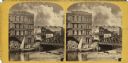
| Date: | |
|---|---|
| Description: | View across the Milwaukee River, showing advertisements for the Riverside Printing House, Book and Job Printing, Spring Street Lager Beer Hall, and Hood an... |

| Date: | 1844 |
|---|---|
| Description: | An ink on paper, hand-drawn map of Milwaukee County that shows the sectioning of townships, the boundary of the canal grant, roads, streams, lakes, includi... |
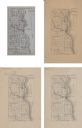
| Date: | 1875 |
|---|---|
| Description: | A series of four, ink on tracing cloth maps of Milwaukee County, Wisconsin that show the topography, the Milwaukee and Menomonee rivers, and railroad of th... |

| Date: | 1976 |
|---|---|
| Description: | An 1876 reprinted map of the Township of Franklin, Milwaukee County, Wisconsin, that shows the land ownership and sectioning of the town, as well as the ro... |

| Date: | 1886 |
|---|---|
| Description: | A hand-colored map of Milwaukee County, Wisconsin that shows the township and range system, sections, towns, roads, railroads and rail stations, cities and... |

| Date: | 1891 |
|---|---|
| Description: | A hand-colored map of Milwaukee County, Wisconsin that shows the township and range system, sections, towns, roads, railroads and rail stations, cities and... |

| Date: | 1896 |
|---|---|
| Description: | A map of Milwaukee County, Wisconsin that shows the township and range system, sections, towns, roads, railroads and rail stations, cities and villages, po... |
If you didn't find the material you searched for, our Library Reference Staff can help.
Call our reference desk at 608-264-6535 or email us at: