 Filter: Categories of Wisconsin Historical Images
Filter: Subject of Rivers
Filter: County of Marinette
Filter: Categories of Wisconsin Historical Images
Filter: Subject of Rivers
Filter: County of Marinette
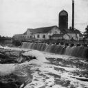
| Date: | 1890 |
|---|---|
| Description: | View of the Peshtigo Company sawmill including the old wooden dam in the foreground. There are logs in the water on the left. |

| Date: | |
|---|---|
| Description: | A bird's-eye view of Marinette looking southwest from the Menominee side of the river. |
| Date: | |
|---|---|
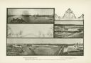
| Description: | A composite of three photographs of the Menominee River with decorative graphics. Views of the river include log drivers and an elevated perspective of the... |

| Date: | |
|---|---|
| Description: | A composite image of three photographs of sawmills and a saw graphic. The sawmills pictured are R.W. Merryman and Co.'s Mill (top), Sawyer & Goodman Co.'s ... |

| Date: | |
|---|---|
| Description: | A composite image of three photographs of sawmills with decorative graphics. The mills are N. Ludington Co.'s Old White Mill (top), the H. Witbeck Co.'s Mi... |
| Date: | 1887 |
|---|---|
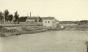
| Description: | View of the boom company office and the site of the old trading post. |

| Date: | 1941 |
|---|---|
| Description: | A tourist map of Marinette County, Wisconsin that includes indexes of the lakes and rivers in the county which also identify the fish present, a list of ra... |

| Date: | 1851 |
|---|---|
| Description: | This manuscript map of the southern portion of the Town of Porterfield, Marinette County, Wisconsin, shows sections and land ownership. The Menominee River... |

| Date: | 1887 |
|---|---|
| Description: | This manuscript map of the southern portion of the Town of Porterfield, Marinette County, Wisconsin, shows sections and land ownership. The Menominee River... |

| Date: | |
|---|---|
| Description: | This 19th century manuscript map shows the southeastern portion of the Town of Stephenson in Marinette County, Wisconsin. Sections, lakes, and streams are ... |

| Date: | 1912 |
|---|---|
| Description: | Shows wards, sections, plat additions, selected buildings, churches, schools, and manufacturing companies. "We have revised this map from H. McCallum’s 189... |

| Date: | 1951 |
|---|---|
| Description: | Water depths shown by bathymetric tints and soundings. Relief shown by contours. "Depths in feet." "Aids to navigation corrected to May 4, 1951." On verso:... |

| Date: | 1910 |
|---|---|
| Description: | Photographic postcard view of High Falls. Caption reads: "High Falls, Crivitz, Wis." |

| Date: | |
|---|---|
| Description: | Aerial view of harbor. In the foreground is a lighthouse and breakwaters. Bridges cross the harbor, and there are factory and industrial buildings near the... |

| Date: | 1912 |
|---|---|
| Description: | This blueprint manuscript map shows selected buildings, roads, and the Peshtigo River. |

| Date: | 1920 |
|---|---|
| Description: | This map shows a small island in the Menominee River and includes a survey table and certification. |

| Date: | 2000 |
|---|---|
| Description: | This map shows Wisconsin Public Service Corporation property, special regulation areas, public boat landings, roads, parks, and other recreation areas. Ins... |

| Date: | 1905 |
|---|---|
| Description: | This photocopied map shows landownership, roads, railroads, rural mail routes, churches, school houses, cemeteries, and townships. The map includes adverti... |

| Date: | 1912 |
|---|---|
| Description: | Marinette County, Township 37 N., Range 20 E. |
If you didn't find the material you searched for, our Library Reference Staff can help.
Call our reference desk at 608-264-6535 or email us at:
