Filter: Categories of Wisconsin Historical Images
Filter: Subject of Rivers
Filter: County of Marathon
Filter: Categories of Wisconsin Historical Images
Filter: Subject of Rivers
Filter: County of Marathon
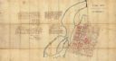
| Date: | 1965 |
|---|---|
| Description: | This map shows lot and block numbers and dimensions, additions, streets, and railroads. |

| Date: | 1919 |
|---|---|
| Description: | Dr. Joseph Smith and his wife, Mary, pose next to trees by a rivers edge. |

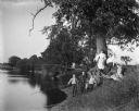
| Date: | 1919 |
|---|---|
| Description: | Dr. Joseph Smith poses with friends next to a tree along a rivers edge. |

| Date: | 1913 |
|---|---|
| Description: | Elevated view of man seated on cliffs edge overlooking the dells of the Eau Claire River. Farther upstream is a bridge over the river. |

| Date: | 1913 |
|---|---|
| Description: | Elevated view of the Eau Claire River rushing over large rocky formations. A bridge crosses over the river on the left. Large tree trunks have been stacked... |

| Date: | 1913 |
|---|---|
| Description: | View up river towards a bridge over a rocky portion of the Eau Claire River. A women is standing on rocks beneath the bridge in the center, while a man sta... |
| Date: | 1913 |
|---|---|
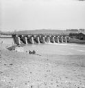
| Description: | View down riverbank towards dam of a river around Wausau. Two men and a limber (two-wheeled cart) are near the rivers edge. A man, perhaps a construction w... |
| Date: | 1913 |
|---|---|
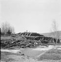
| Description: | View from low hill of piles of logs along the icy rivers edge. A pile of logs is on the shoreline, and a large amount of neatly stacked logs are in the bac... |

| Date: | 1913 |
|---|---|
| Description: | View from riverbank looking down towards two girls standing in the middle of a bridge along a road. They are looking over the railing at the water below. F... |
| Date: | 1910 |
|---|---|
| Description: | Several members of the Krueger and Backhause families fishing along the bank of the Rock River. Mr. and Mrs. Backhouse and Florentina and Jennie Krueger ar... |
| Date: | 1857 |
|---|---|
| Description: | This manuscript map is ink and watercolor on tracing cloth and shows bridges, lots, and streets. Some of the lots are in pink ink. The left of the map incl... |

| Date: | 1987 |
|---|---|
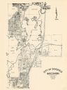
| Description: | This pictorial map shows roads, bridges, local businesses with phone numbers, and public buildings. Relief is shown pictorially. Also included is a calen... |

| Date: | 1951 |
|---|---|
| Description: | This map shows land use, dwellings, resorts, camps, marshes, springs, dams, lake bottom composition, and access. The map includes a fish species table, geo... |

| Date: | 1935 |
|---|---|
| Description: | Slightly elevated view of the Eau Claire River flowing between block-like rock formations downstream from a stone bridge in the Dells of the Eau Claire Cou... |

| Date: | 1901 |
|---|---|
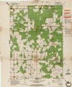
| Description: | A plat map of Marathon county, 28 township, north range, 7 east. |

| Date: | 1901 |
|---|---|
| Description: | A plat map of Marathon county, township 28, north range, 8 east. |

| Date: | 1901 |
|---|---|
| Description: | A plat map of Marathon county, township 29, north range, 6 east. |

| Date: | 1901 |
|---|---|
| Description: | A plat map of Marathon county, township 29, north range, 7 east. |
If you didn't find the material you searched for, our Library Reference Staff can help.
Call our reference desk at 608-264-6535 or email us at: