Filter: Categories of Wisconsin Historical Images
Filter: Subject of Rivers
Filter: County of Marathon
Filter: Subject of cities and towns
Filter: Categories of Wisconsin Historical Images
Filter: Subject of Rivers
Filter: County of Marathon
Filter: Subject of cities and towns

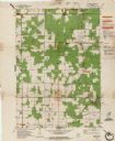
| Date: | 1943 |
|---|---|
| Description: | This photocopy map shows inhabited farms, rivers, roads, and mills in the vicinity of Marathon City [and village of Edgar], including area between the Big ... |
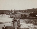
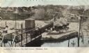
| Date: | 1900 |
|---|---|
| Description: | View of the Wausau mill and dam next to the river, where logs were first sorted. |
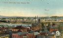
| Date: | |
|---|---|
| Description: | View over rooftops of town. A river is on the left, with a neighborhood on higher ground beyond. Caption reads: "Bird's-Eye View, Wausau, Wis." |
| Date: | 1905 |
|---|---|
| Description: | Elevated view toward the lumber company. A bridge over a river is in the foreground. Caption reads: "Looking South from City Hall Tower, Wausau, Wis." |
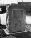
| Date: | 1929 |
|---|---|
| Description: | View of the George Stevens marker with the Wisconsin Auto Supply Company in the background and the Wisconsin River. |

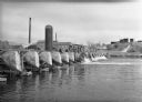
| Date: | 1880 |
|---|---|
| Description: | Clark's Saw and Planing Mill in the right foreground which is now the site of the electric plant. Behind Clark's is Plummers Mill where the Vocational Scho... |
| Date: | 1905 |
|---|---|
| Description: | Elevated view of the railroad station looking west. A bridge over the river is in the foreground, and a large water tower is across the railroad tracks on ... |
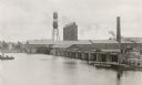
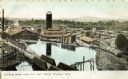
| Date: | 1915 |
|---|---|
| Description: | Elevated view of the Marathon Paper Mills from across the river. Caption reads: "Scene at the Marathon Paper Mills, Wausau, Wis." |
| Date: | |
|---|---|
| Description: | A view of the Alexander Stewart Lumber Company, at 502 3rd Street. Several men are fishing off the bridge/dam over the river. |

| Date: | 1965 |
|---|---|
| Description: | Map shows original plat, plat additions, and lot measurements for Rothschild, Wisconsin. Lake Wausau and the Wisconsin River are labelled. Map reads: "Comp... |
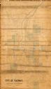
| Date: | 1892 |
|---|---|
| Description: | This map shows lot and block numbers and dimensions, some landownership, wards, railroads, streets, and mills. The map includes 5 plat additions that have ... |
| Date: | 1965 |
|---|---|
| Description: | This map shows lot and block numbers and dimensions, additions, streets, and railroads. |
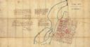
| Date: | 1857 |
|---|---|
| Description: | This manuscript map is ink and watercolor on tracing cloth and shows bridges, lots, and streets. Some of the lots are in pink ink. The left of the map incl... |

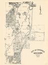
| Date: | 1987 |
|---|---|
| Description: | This pictorial map shows roads, bridges, local businesses with phone numbers, and public buildings. Relief is shown pictorially. Also included is a calen... |

| Date: | 1901 |
|---|---|
| Description: | A plat map of Marathon county, 28 township, north range, 7 east. |

| Date: | 1901 |
|---|---|
| Description: | A plat map of Marathon county, township 28, north range, 8 east. |

| Date: | 1901 |
|---|---|
| Description: | A plat map of Marathon county, township 29, north range, 6 east. |

| Date: | 1901 |
|---|---|
| Description: | A plat map of Marathon county, township 29, north range, 7 east. |
If you didn't find the material you searched for, our Library Reference Staff can help.
Call our reference desk at 608-264-6535 or email us at: