Filter: Categories of Wisconsin Historical Images
Filter: Subject of Rivers
Filter: County of Marathon
Filter: Creator Name of Unknown
Filter: Categories of Wisconsin Historical Images
Filter: Subject of Rivers
Filter: County of Marathon
Filter: Creator Name of Unknown
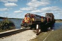
| Date: | |
|---|---|
| Description: | View of the Wisconsin Central Railroad crossing a railroad bridge at Knowlton. |
| Date: | |
|---|---|
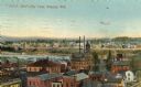
| Description: | View over rooftops of town. A river is on the left, with a neighborhood on higher ground beyond. Caption reads: "Bird's-Eye View, Wausau, Wis." |
| Date: | 1905 |
|---|---|
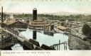
| Description: | Elevated view toward the lumber company. A bridge over a river is in the foreground. Caption reads: "Looking South from City Hall Tower, Wausau, Wis." |
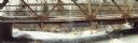
| Date: | |
|---|---|
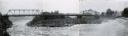
| Description: | Panoramic view of the old Highway 153 bridge over the Wisconsin River at Mosinee. |

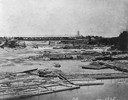
| Date: | 1880 |
|---|---|
| Description: | Clark's Saw and Planing Mill in the right foreground which is now the site of the electric plant. Behind Clark's is Plummers Mill where the Vocational Scho... |
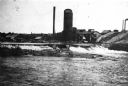
| Date: | 1905 |
|---|---|
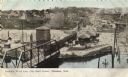
| Description: | Elevated view of the railroad station looking west. A bridge over the river is in the foreground, and a large water tower is across the railroad tracks on ... |

| Date: | 11 30 1989 |
|---|---|
| Description: | Panoramic view of the bridge over the frozen Eau Claire River. |
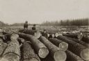
| Date: | 1900 |
|---|---|
| Description: | Two women and one man in street clothes and wearing hats posing among the logs of a large log jam on the Wisconsin River. |

| Date: | |
|---|---|
| Description: | Letterhead of Carl Stargardt, bridge contractor in Athens, Wisconsin, with two-color illustrations in brown and green inks of an automobile heading toward ... |

| Date: | 1901 |
|---|---|
| Description: | A plat map of Marathon county, 28 township, north range, 7 east. |

| Date: | 1901 |
|---|---|
| Description: | A plat map of Marathon county, township 28, north range, 8 east. |

| Date: | 1901 |
|---|---|
| Description: | A plat map of Marathon county, township 29, north range, 6 east. |

| Date: | 1901 |
|---|---|
| Description: | A plat map of Marathon county, township 29, north range, 7 east. |

| Date: | 1901 |
|---|---|
| Description: | A plat map of Marathon county, township 29, north range, 8 east. |
If you didn't find the material you searched for, our Library Reference Staff can help.
Call our reference desk at 608-264-6535 or email us at: