Filter: Categories of Wisconsin Historical Images
Filter: Subject of Rivers
Filter: County of Lincoln
Filter: Subject of rivers
Filter: Categories of Wisconsin Historical Images
Filter: Subject of Rivers
Filter: County of Lincoln
Filter: Subject of rivers
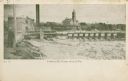
| Date: | 1909 |
|---|---|
| Description: | The Lindaur Mill Flume. A man is standing in the left foreground. In the distance is the Court House with clocktower. Caption reads: "Lindaur Mill Flume, M... |
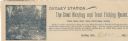
| Date: | |
|---|---|
| Description: | Letterhead of Dudley Station, a hunting and trout fishing resort in Dudley, Wisconsin. On the left is an illustration of a fisherman holding a fishing pole... |
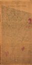
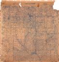
| Date: | 1872 |
|---|---|
| Description: | Shows what is currently Lincoln County and portions of Vilas, Oneida, Iron, and Langlade counties. Includes manuscript annotations of marked land tracts. |
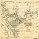
| Date: | 1930 |
|---|---|
| Description: | This map of Tomahawk shows landownership, an original plat of the city, various plat additions, roads, and railroads. The map includes annotations of road ... |
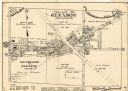
| Date: | 1943 |
|---|---|
| Description: | This map of the Village of Gleason shows land ownership by name, local streets, railroads, churches, schools, and part of Prairie River. The bottom left of... |

| Date: | 1982 |
|---|---|
| Description: | This standard U.S.G.S. topographic map was annotated by civil engineer and railroad historian James P. Kaysen to show the location of existing and defunct ... |

| Date: | 1902 |
|---|---|
| Description: | A plat map of Lincoln County showing Township 34 North, Range 8 East. |

| Date: | |
|---|---|
| Description: | A photocopy of the T.34N, R.8E portion of a map of Lincoln County. |
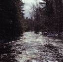
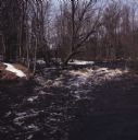
| Date: | 04 1971 |
|---|---|
| Description: | View down center of the Prairie River. Snow and trees line both shorelines. |
| Date: | 04 1971 |
|---|---|
| Description: | View across river towards a snowy shoreline along the Prairie River. |

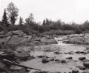
| Date: | |
|---|---|
| Description: | View along shoreline towards the stone bridge with three arches over the Prairie River. There is a stone wall along the opposite shoreline near the bridge.... |
If you didn't find the material you searched for, our Library Reference Staff can help.
Call our reference desk at 608-264-6535 or email us at: