Filter: Categories of Wisconsin Historical Images
Filter: Subject of Rivers
Filter: County of Langlade
Filter: Categories of Wisconsin Historical Images
Filter: Subject of Rivers
Filter: County of Langlade
| Date: | 1930 |
|---|---|
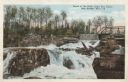
| Description: | View looking up toward the falls and bridge at the Dells of Eau Claire. Caption reads: "Scene at the Dells of Eau Claire, near Antigo, Wis." |

| Date: | |
|---|---|
| Description: | View of the shoreline and South Bridge suspended over the Eau Claire River. Caption reads: "South Bridge, Eau Claire River, Antigo, Wis." |

| Date: | 10 02 1907 |
|---|---|
| Description: | Photographic postcard view looking up at twelve workers wearing hats posing on top of the Dells Dam on the Wolf River. Water is flowing through the dam at ... |

| Date: | 1908 |
|---|---|
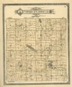
| Description: | A map of Langlade County, Wisconsin that shows the townships and ranges, towns, cities and villages, wagon roads, churches, schools, lakes, rivers, railroa... |

| Date: | 1909 |
|---|---|
| Description: | A map of Langlade County, Wisconsin that shows townships and ranges, towns, cities and villages, wagon roads, churches, schools, sawmills, town halls, chee... |

| Date: | 1947 |
|---|---|
| Description: | This map shows lakes, rivers, railroads, and the soil types of Langlade County. Legends of soil types, conventional signs, and stoniness and slope are incl... |

| Date: | 1960 |
|---|---|
| Description: | This pictorial map shows recreation activities, rivers, lakes, and the history of the area. The map covers Langlade County and parts of adjacent counties. ... |

| Date: | 1966 |
|---|---|
| Description: | This map shows trails, roads, creeks, alleged location of George Gardner's trading post, Boulder and Mud Lakes, and a portion of the Wolf River. The map al... |
| Date: | 1913 |
|---|---|
| Description: | A plat map of the township of Norwood in Langlade County. |
| Date: | |
|---|---|
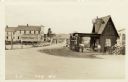
| Description: | Photographic postcard view of the road through a small settlement. A dwelling and a service station are on the right. A general store on the left is on the... |
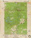
| Date: | 1973 |
|---|---|
| Description: | This standard U.S.G.S. topographic map was annotated by civil engineer and railroad historian James P. Kaysen to show the location of existing and defunct ... |

| Date: | 1979 |
|---|---|
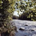
| Description: | Two canoeists navigate the rapids, called Gilmore's Mistake, on the Wolf River. Rocks and foliage can be seen on the shore. |
If you didn't find the material you searched for, our Library Reference Staff can help.
Call our reference desk at 608-264-6535 or email us at: