 Filter: Categories of Wisconsin Historical Images
Filter: Subject of Rivers
Filter: County of Kenosha
Filter: Categories of Wisconsin Historical Images
Filter: Subject of Rivers
Filter: County of Kenosha
| Date: | |
|---|---|
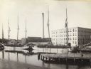
| Description: | The buildings of Allen & Sons Tannery, with boats carrying supplies in the foreground. |
| Date: | |
|---|---|
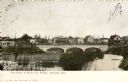
| Description: | The Middle Street bridge over the Pike River. Caption reads: "Pike River & Middle St. Bridge, Kenosha, Wis." |
| Date: | 1920 |
|---|---|
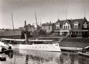
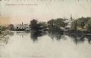
| Description: | The Morgan Club House on the river. A long, narrow excursion boat is moored on the dock in front of the club. |

| Date: | 08 31 1963 |
|---|---|
| Description: | View of a private boat marina, as seen from a park. |

| Date: | 1946 |
|---|---|
| Description: | International truck utilized by K*A*T Corporation for multi-automobile hauling. The truck is parked on a road with a river in the background. |

| Date: | 10 19 1836 |
|---|---|
| Description: | This 1836 manuscript map shows the sections, windfalls, marshes, streams, prairies, acreages, and former mouth of the Pike River in what is now the eastern... |

| Date: | 08 17 1874 |
|---|---|
| Description: | This manuscript drawing provides a side elevation, plan, and perspective view for a proposed lock on the Fox River. |

| Date: | 1892 |
|---|---|
| Description: | This map shows the dams and locks of the Fox River between Neenah, in Winnebago County, Wisconsin, and Kaukauna, in Outagamie County. The cities and villag... |

| Date: | 1906 |
|---|---|
| Description: | This map, which shows the Fox River and the likely location of a Mascoutin village near Berlin, Wisconsin, was published in the Proceedings of the State Hi... |

| Date: | 1906 |
|---|---|
| Description: | This map, which shows the Mascoutin village site near Berlin, Wisconsin, the Fox River, and parts of the Wisconsin and Wolf Rivers, was published in the Pr... |

| Date: | 1905 |
|---|---|
| Description: | This pictorial representation of part of Lake Winnebago and the Fox River in 1703, showing interactions between white beaver hunters and the Iroquois is ta... |
| Date: | 1934 |
|---|---|
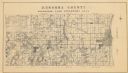
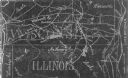
| Description: | A land inventory map of Kenosha County. The top left features a legend of "Land Cover" and "Roads and Other Improvements". Lake Michigan is labelled to the... |

| Date: | 1910 |
|---|---|
| Description: | This map is a survey of Kenosha Harbor and shows local streets, public buildings, local businesses, and part of Lake Michigan. Included is text on sailing ... |

| Date: | 1959 |
|---|---|
| Description: | This map shows public access sites, public beaches and parks, other public shorelines, boat liveries, public hunting and fishing grounds, railroads, roads,... |
| Date: | 1954 |
|---|---|
| Description: | This photocopy map shows a early sketch of the settlement Southport. Rivers, lakes, other settlements, county boundaries, and roads are labeled. A portion ... |
| Date: | 08 20 1909 |
|---|---|
| Description: | Text on front: "West Bank of the Fox, at Wilmot, Wis." View of a town from the Fox River. Trees and buildings are along the bank. A church steeple is in th... |
If you didn't find the material you searched for, our Library Reference Staff can help.
Call our reference desk at 608-264-6535 or email us at:
