 Filter: Categories of Wisconsin Historical Images
Filter: Subject of Rivers
Filter: County of Jefferson
Filter: Categories of Wisconsin Historical Images
Filter: Subject of Rivers
Filter: County of Jefferson
| Date: | 1906 |
|---|---|
| Description: | A bridge with a lighted entrance arch reading "Tivoli" leads to Tivoli Island. |

| Date: | |
|---|---|
| Description: | View down curve in road toward people crossing a bridge over the Rock River near factory buildings. |

| Date: | |
|---|---|
| Description: | View of a wooden bridge spanning the Bark River. Probably late fall or early spring as the trees are leafless. Caption reads: "Bark River Bridge, Fort Atki... |

| Date: | 09 1884 |
|---|---|
| Description: | Sanborn map of Fort Atkinson including Barrie, Germany, and North Water Streets. |

| Date: | 09 1884 |
|---|---|
| Description: | Sanborn map of Fort Atkinson including South Water and Milwaukee Streets. |
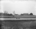
| Date: | 05 1900 |
|---|---|
| Description: | View of the Herman Backhaus farm buildings from across the Rock River. Four people are sitting in a rowboat. Other people are standing along the shoreline ... |

| Date: | 06 1900 |
|---|---|
| Description: | Groups of people cross a wooden bridge on Concordia, later Tivoli, Island. |

| Date: | 04 1900 |
|---|---|
| Description: | Men standing on either side of the river, fishing near the rough and ready dam. In the background is the Octagon House, built in 1854. |

| Date: | 05 1901 |
|---|---|
| Description: | Children are standing along the shoreline watching young boys standing in boats fishing with dip nets in the Crawfish River. In the background is a bridge ... |
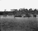
| Date: | 1901 |
|---|---|
| Description: | Boys are standing on boats, catching red horse fish using dip nets in the Crawfish River. The dip nets are set up on scaffolds in the river. In the backgro... |
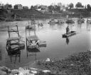
| Date: | 1901 |
|---|---|
| Description: | View from shoreline of a man standing in a boat, dipping for carp on the Crawfish River. Behind him dip nets are set up on scaffolds in the river. There ar... |
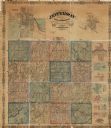
| Date: | 1862 |
|---|---|
| Description: | This map shows townships, landownership, roads, railroads, and swampland in Jefferson County. There is an inset maps showing the towns of: Watertown, Jeffe... |

| Date: | |
|---|---|
| Description: | An ink and watercolor on tracing map showing the sections and surveyed lots in the vicinity of the Rock and Crawfish rivers in the central and eastern port... |

| Date: | 1870 |
|---|---|
| Description: | Bird’s-eye view map. "Looking north east." Indexed for points of interest. Shows homes, businesses, and the Bark and Rock River. Streets running west to ea... |

| Date: | 1920 |
|---|---|
| Description: | Shows ward boundaries, corporation limits, plat of town, land ownership by name, local streets, parks, railroads, and parts of Rock River. Wards appear in ... |

| Date: | 1947 |
|---|---|
| Description: | Lower left hand corner features a legend. "Drawn 1938, revised 1947." Shows water mains, hydrants, corporation limits, city ward divisions, fire proof buil... |

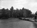
| Date: | 1912 |
|---|---|
| Description: | Elevated view of the river with trees on the left. On the right, two young boys are fishing from a rowboat in the river near a landing at the back of a thr... |

| Date: | 1840 |
|---|---|
| Description: | Map shows three Wisconsin territories, Jefferson, Waukesha, and Milwaukee. Map is ink, pencil, and watercolor on paper. Relief shown by hachures. |

| Date: | |
|---|---|
| Description: | Photographic postcard view from shoreline of an old bridge over the Rock River. Caption reads: "Old Bridge, Aztalan, Wis." |

| Date: | 1940 |
|---|---|
| Description: | This map of Aztalan is pencil and ink on paper. The map shows streets, local businesses, churches, houses, and the Crawfish River. The map reads: "Informat... |
If you didn't find the material you searched for, our Library Reference Staff can help.
Call our reference desk at 608-264-6535 or email us at: