 Filter: Categories of Wisconsin Historical Images
Filter: Subject of Rivers
Filter: County of Green
Filter: Categories of Wisconsin Historical Images
Filter: Subject of Rivers
Filter: County of Green
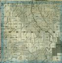
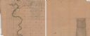
| Date: | 1861 |
|---|---|
| Description: | A detail from a map of Green County, showing only Decatur. |

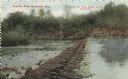
| Date: | 06 13 |
|---|---|
| Description: | Photographic postcard of the Sugar River. Elevated view of buildings and trees lining the shoreline. Two men can be seen standing next to the dam among a p... |
| Date: | |
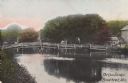
|---|---|
| Description: | Colorized postcard view of the Decatur Dam. The shoreline and trees are visible in the background. Text at the top reads: "Decatur Dam, Brodhead, Wis." |

| Date: | |
|---|---|
| Description: | Colorized postcard view of the Old Clarance Bridge, a covered bridge. Text in red in the upper right corner reads: "Old Clarance Bridge, Brodhead, Wis." |
| Date: | |
|---|---|
| Description: | Colorized postcard view of the Cow Bridge. A farm is on the shoreline on the right. A man is standing on the bridge. Text in the lower right corner reads: ... |

| Date: | 07 13 1909 |
|---|---|
| Description: | Elevated view toward the dam. The shoreline is lined with trees, and there are buildings near the dam on the right Caption reads: "Albany, Wis." |

| Date: | |
|---|---|
| Description: | View from shoreline of railroad bridge across a river. Two girls and a boy are standing on the opposite side of the river near the shoreline. |

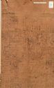
| Date: | 1861 |
|---|---|
| Description: | Shows townships and sections, landowners, and woodlands. Includes inset maps of Monroe, Brodhead, Albany, Cadiz, Decatur, Dayton, Clarence, Springfield, Tw... |
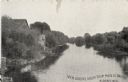
| Date: | |
|---|---|
| Description: | Elevated view of Sugar River. The banks are mainly lined with trees. There are houses and other wooden structures along the east bank. Caption reads: "View... |
| Date: | |
|---|---|
| Description: | Hand-drawn map of the town of Cadiz, Wisconsin near the Illinois border showing plots of landownership. The map also includes one landmark of the Pecatonic... |

| Date: | |
|---|---|
| Description: | A map of the Pecatonica River and Sugar River watersheds in Township 3 North through Township 5 North, by Range 4 East through Range 8 East, which include ... |
| Date: | 1850 |
|---|---|
| Description: | A hand-drawn plat map of the area along the Pecatonica River in the Town of Cadiz, Green County, Wisconsin. |

| Date: | 1926 |
|---|---|
| Description: | A topographic map of Green County, showing by contours and spot heights the topographic and natural features of the county. The contour intervals are 20 fe... |

| Date: | 1906 |
|---|---|
| Description: | A map of Berlin, Wisconsin and the surrounding area, showing the old channel of the Fox River and the site of Mascouten village just south of that city in ... |

| Date: | 1969 |
|---|---|
| Description: | A map of the Elroy-Sparta State Trail and the surrounding area, showing the townships, the towns of Cashton, Sparta, in the west, and Union Center and Elro... |

| Date: | 1856 |
|---|---|
| Description: | This map of Brohead shows land and lot ownerships by name and color, as well as roads, and railroads. |

| Date: | 1857 |
|---|---|
| Description: | This map shows rural landownership and acreages, lot and block numbers, selected buildings, roads, railroads, and public squares. The map is indexed for th... |

| Date: | 1908 |
|---|---|
| Description: | A Sanborn fire map of Brodhead. Includes an inset at top right showing distances from P.O. |
If you didn't find the material you searched for, our Library Reference Staff can help.
Call our reference desk at 608-264-6535 or email us at: