 Filter: Categories of Wisconsin Historical Images
Filter: Subject of Rivers
Filter: County of Grant
Filter: Categories of Wisconsin Historical Images
Filter: Subject of Rivers
Filter: County of Grant

| Date: | 1869 |
|---|---|
| Description: | Birds-eye drawing of Boscobel, Grant County, depicts street names and street layouts, houses, rivers and trees. A reference key at the bottom of the map sh... |

| Date: | 1875 |
|---|---|
| Description: | Bird's-eye map of Platteville. |

| Date: | 1947 |
|---|---|
| Description: | The Passenger Pigeon Monument was designed and built around 1947. It was erected by the Wisconsin Society for Ornithology. |

| Date: | |
|---|---|
| Description: | Plan of township no. 3 north, range no. 5 west of the 4th principal meridian. |

| Date: | 1912 |
|---|---|
| Description: | Sanborn insurance map of the main street in Potosi, Wisconsin, with an inset for the Potosi Brewery. |
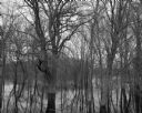
| Date: | 04 18 1965 |
|---|---|
| Description: | View of a wooded area affected by a Wisconsin River flood. |
| Date: | |
|---|---|
| Description: | Bird's-eye view of Bloomington. In the open space, there are trees and a creek. In the developed area, there are stores, apartments, and barns. The buildin... |
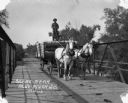
| Date: | 1913 |
|---|---|
| Description: | A man drives a team of horses pulling a wagon across a bridge. The man is standing atop the barreled goods, holding the reins. There is dung on the road. |
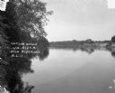
| Date: | 1913 |
|---|---|
| Description: | A view across the river. Trees are along the left shoreline. |

| Date: | |
|---|---|
| Description: | View of a bridge over a stream. In the foreground is a tree. Residential homes are in the distance. |
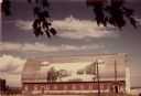
| Date: | 07 1949 |
|---|---|
| Description: | Gothic roofed barn with river scene painted on its roof by Frank Engebretson. |

| Date: | 1835 |
|---|---|
| Description: | Plat for a proposed Sinsinawa City (never built), in Grant County, Wis. When it became clear in the mid-1830s that Wisconsin Territory would be established... |

| Date: | 1900 |
|---|---|
| Description: | View from ice-covered river of Dripping Springs along shoreline in winter. |

| Date: | |
|---|---|
| Description: | A map of Grant County, Wisconsin that shows the townships, cities, villages, rivers and streams, roads and railroads, landownership, post offices. The map... |

| Date: | |
|---|---|
| Description: | A map of Grant County, Wisconsin showing the locations of townships, towns, cities, villages, roads, railroads, schools, cemeteries, churches, rivers, and ... |
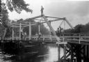
| Date: | |
|---|---|
| Description: | View from shoreline of group of people posing on a bridge across a small river near Cassville, probably in Grant County. The group of people, three women, ... |

| Date: | 1857 |
|---|---|
| Description: | Relief shown by hachures. "Lith. of Ed. Mendel, Chicago." Shows townships and sections, rivers, roads, railroads, houses, flour mills, saw mills, furnaces... |

| Date: | 1972 |
|---|---|
| Description: | Ink on tracing paper. This map shows rivers, Prairie du Chien, site of Fort Crawford, Excelsior, Fort Andrew, Boscobel, Blue River, Orion, Muscoda, Castle ... |

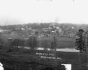
| Date: | |
|---|---|
| Description: | View over town, including hotel and church, towards the Mississippi River. The far shoreline and bluffs are in the distance. |
If you didn't find the material you searched for, our Library Reference Staff can help.
Call our reference desk at 608-264-6535 or email us at:
