 Filter: Categories of Wisconsin Historical Images
Filter: Subject of Rivers
Filter: County of Fond du Lac
Filter: Categories of Wisconsin Historical Images
Filter: Subject of Rivers
Filter: County of Fond du Lac

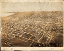
| Date: | 1867 |
|---|---|
| Description: | Birds eye drawing of Fond du Lac depicts street names and street layouts, houses, buildings, trees, and the Fond du Lac River. A reference key at the botto... |

| Date: | 1867 |
|---|---|
| Description: | Bird's-eye map of Ripon, with insets of points of interest. |

| Date: | 1885 |
|---|---|
| Description: | Bird's-eye map of Waupun on the Rock River. There is an inset at top center of "Althouse, Wheeler & Co., Windmills and Pumps." |

| Date: | 1920 |
|---|---|
| Description: | Site where the first French trading post in Wisconsin was built at the fork of the Fond du Lac River in 1787. The site is located near the city's gas plant... |

| Date: | 1857 |
|---|---|
| Description: | Quarter section of a map of the city of Fond du Lac featuring an illustration of the Lewis House. |

| Date: | |
|---|---|
| Description: | Lithograph view towards river of the American Fur Companies buildings and fenced enclosures, surrounded by hills and trees. |

| Date: | 1870 |
|---|---|
| Description: | View across water toward the back side of a railroad station and outbuilding that face the creek. A hotel, garage, and homes are around the structure. |
| Date: | |
|---|---|
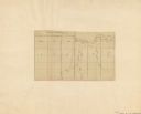
| Description: | Map shows rivers and acreages in part of Fond du Lac township and Fond du Lac, Wisconsin. |

| Date: | 1840 |
|---|---|
| Description: | Shows plat of town, local streets, Fond du Lac River, and part of Lake Winnebago. |
| Date: | 1867 |
|---|---|
| Description: | Bird’s-eye view map. Indexed for points of interest. |

| Date: | 1916 |
|---|---|
| Description: | Includes index to businesses, churches, and schools. Shows local streets, buildings, railroads, ward divisions, Fond du Lac River, and part of Lake Winneba... |

| Date: | 1956 |
|---|---|
| Description: | Includes street index. Shows local streets, parks, highways, railroads, Fond du Lac River, and part of lake Winnebago. Also includes text on points of inte... |

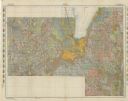
| Date: | 1956 |
|---|---|
| Description: | Includes street index and index to points of interest. Shows land ownership by name, plat of town, local streets, schools, parks, highways, railroads, ward... |

| Date: | 1800 |
|---|---|
| Description: | Shows plat of town, land ownership by name, local streets, courthouses, churches, hotels, mills, railroads, railroad stations, lakes, and rivers. Includes ... |

| Date: | 1800 |
|---|---|
| Description: | Ink and watercolor on tracing paper. Shows plat of town, local streets, Fond du Lac River, and part of Lake Winnebago. |
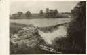
| Date: | 1910 |
|---|---|
| Description: | View of a river with a dam waterfall. A road runs along the far side of the river, and a large barn is across the road on the right. Caption reads: "Scenic... |
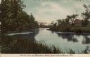
| Date: | 1910 |
|---|---|
| Description: | Colorized postcard view of a river scene and neighboring farm. Caption reads: "Scenic View on Milwaukee River, near Campbellsport, Wis." |

| Date: | 1857 |
|---|---|
| Description: | This map has relief shown by hachures and pictorially and shows plat of the town, wards, lots, land ownership by name, local roads, highways, railroads, pa... |
| Date: | 1911 |
|---|---|
| Description: | This map shows soil types, lakes, rivers, and railroads. A key of soil profiles and a legend of soil types is included. The bottom margin reads: "Soils su... |
If you didn't find the material you searched for, our Library Reference Staff can help.
Call our reference desk at 608-264-6535 or email us at:
