 Filter: Categories of Wisconsin Historical Images
Filter: Subject of Rivers
Filter: County of Dunn
Filter: Year of 1800-1899
Filter: Categories of Wisconsin Historical Images
Filter: Subject of Rivers
Filter: County of Dunn
Filter: Year of 1800-1899

| Date: | 1875 |
|---|---|
| Description: | Bird's-eye map of Menomonie, with an inset of the County Court House. Spelled Menomonee on map. |

| Date: | 1875 |
|---|---|
| Description: | Stereograph elevated view of a river and homes of Menomonie. |
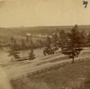
| Date: | 1880 |
|---|---|
| Description: | The view of Red Cedar River from Meadow Hill. |

| Date: | 1880 |
|---|---|
| Description: | Elevated view of Red Cedar (or Menomonie) River and the Knapp, Stout & Co., mills from the top of present day Meadow Hill Dr. looking Southeast. |

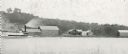
| Date: | 1899 |
|---|---|
| Description: | Elevated view looking north towards Menomonie, the Knapp, Stout and Company lumber mills. |
| Date: | 1895 |
|---|---|
| Description: | Rumsey's Landing on the Chippewa River about two miles below Caryville. |

| Date: | 1860 |
|---|---|
| Description: | Pencil and ink on paper. "Showing the government meander line on the left bank of Rock River and the actual course of Rock River together with the several ... |

| Date: | 1855 |
|---|---|
| Description: | Map reads: "Knapp, Stout & Co., William Carson, Henry Eaton, Amos Collum, William Wilson & C.S. Bundy Proprietors."Streets running horizontally begin at th... |

| Date: | 1890 |
|---|---|
| Description: | Shows plat of town, local streets, steam boat landings, and Chippewa River. Public square and Muskoo Island hand-colored. Map reads: "Full Lots are 125x66 ... |

| Date: | 1875 |
|---|---|
| Description: | This plat map shows local streets, buildings, numbered blocks and lots, part of the Red Cedar River, and land ownership by name. Also included is a busines... |

| Date: | 1896 |
|---|---|
| Description: | This map shows plat of town, local streets, numbered blocks and lots, mill pond, mills, part of the Red Cedar River, and land and property ownership by nam... |
If you didn't find the material you searched for, our Library Reference Staff can help.
Call our reference desk at 608-264-6535 or email us at: