 Filter: Categories of Wisconsin Historical Images
Filter: Subject of Rivers
Filter: County of Dodge
Filter: Categories of Wisconsin Historical Images
Filter: Subject of Rivers
Filter: County of Dodge

| Date: | 1913 |
|---|---|
| Description: | View of the Short Bridge over the Rock River at Horicon. Two men are in a small boat in the river. Caption reads: "Short Bridge, Horicon, Wis." |

| Date: | 1912 |
|---|---|
| Description: | View from shoreline toward a bridge over the Rock River. A boat with three men is passing underneath the bridge. Caption reads: "'Wood's' Bridge South of H... |

| Date: | |
|---|---|
| Description: | Elevated view of a completely burned building in downtown Horicon at the river. A cigar store is next door, and men are gathered on the bridge. |

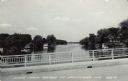
| Date: | 1907 |
|---|---|
| Description: | Elevated view across water towards a bridge over the Rock River. Buildings in the town of Horicon are in the background. |
| Date: | 1961 |
|---|---|
| Description: | View of the Rock River from a bridge at Hustisford. The river is lined with boathouses. Caption reads: "Scene from Bridge at Hustisford, Wis." |
| Date: | 07 1971 |
|---|---|
| Description: | View looking upriver towards the Jaeger Rye Mill, also known as the Danville Mill, on the left in front of a small dam. Trees are along the banks of the Cr... |
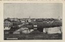
| Date: | 1909 |
|---|---|
| Description: | View of Kekoskee from across the Rock River. Caption reads: "Kekoskee, Wis." |
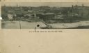
| Date: | |
|---|---|
| Description: | Aerial panoramic view of central Mayville over a frozen river. Caption reads: "All Roads Lead to Mayville, Wis." |

| Date: | 1908 |
|---|---|
| Description: | View from shoreline looking toward a dam and bridge on the Rock River near Mayville. Two men are standing on the bridge. Caption reads: "Lower Dam, Mayvill... |

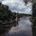
| Date: | 1915 |
|---|---|
| Description: | View of the Upper Dam on the Rock River near Mayville. A church is on the hill on the left. Caption reads: "Upper Dam, Mayville, Wis." |

| Date: | 1909 |
|---|---|
| Description: | View of the bridge crossing the Rock River at Bridge Street. People are in rowboats on the river. Caption reads: "Bridge Street Bridge, Mayville, Wis." |
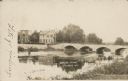
| Date: | 1907 |
|---|---|
| Description: | Text on front reads: "Bridge Scene, Theresa, Wis." The stone arch bridge over the East Branch Rock River was built in 1874, replacing the original bridge b... |

| Date: | 1910 |
|---|---|
| Description: | A land ownership map of the township of Leroy. |
If you didn't find the material you searched for, our Library Reference Staff can help.
Call our reference desk at 608-264-6535 or email us at: