 Filter: Categories of Wisconsin Historical Images
Filter: Subject of Rivers
Filter: County of Dane
Filter: Categories of Wisconsin Historical Images
Filter: Subject of Rivers
Filter: County of Dane

| Date: | 1899 |
|---|---|
| Description: | A map of the east part of the city of Madison, including a portion of the isthmus. |

| Date: | 1961 |
|---|---|
| Description: | This street map includes an ancillary map of Dane County highways and a business directory. Lake Mendota, Lake Monona, Monona Bay, Yahara River, and Lake W... |

| Date: | 1900 |
|---|---|
| Description: | This map shows the additions made in January 1855, as well as houses, streets, Catfish Creek, and the Milwaukee and Mississippi Rail Road and Depot. It als... |
| Date: | |
|---|---|
| Description: | Watercolor painting of the Yahara River, somewhere between Lake Monona and Lake Mendota. |
| Date: | 1906 |
|---|---|
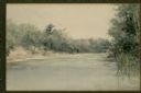
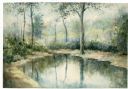
| Description: | Watercolor painting of the Yahara River at Lake Monona. |

| Date: | 1906 |
|---|---|
| Description: | Watercolor painting of the Yahara River at Lake Monona, with trees in the background and wetlands in the foreground. |
| Date: | |
|---|---|
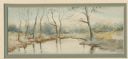
| Description: | Watercolor painting of the Yahara River in winter near Lake Monona. The trees are reflected in the ice. |

| Date: | 1906 |
|---|---|
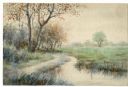
| Description: | Watercolor painting of the Yahara River, with large trees on the shoreline. Note: '05 & '06 were the years when Tenney Park and the Yahara River Parkway ... |
| Date: | |
|---|---|
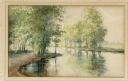
| Description: | Watercolor painting of the Yahara River north of Lake Mendota. Trees are on the banks to the left with foliage throughout. A meadow is on the right. |
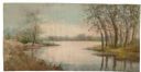
| Date: | |
|---|---|
| Description: | Watercolor painting of the Yahara River with trees and foliage on the banks. In the background trees line the far shore. |
| Date: | |
|---|---|
| Description: | Watercolor painting of the Yahara River. Trees and foliage line the banks. |

| Date: | |
|---|---|
| Description: | Watercolor painting of the Yahara River at Lake Monona with some added elements. Trees are along the banks, and a fence is on the right. |

| Date: | 1921 |
|---|---|
| Description: | This map, oriented with north to the upper right, shows roads, railroads, and points of interest. Lake Mendota, Wingra, Monona, Waubesa, Mud, Hook, Island,... |

| Date: | |
|---|---|
| Description: | View across pond towards three boys standing on the board walkway of the spillway at Lake Mendota and the Yahara River. In the background is the far shorel... |
| Date: | |
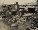
|---|---|
| Description: | View from shoreline towards Sid Boyum fishing while standing on a pile of rocks near a river. Near Sid on the opposite shoreline is a collapsed building on... |

| Date: | 1925 |
|---|---|
| Description: | This map oriented with north to the upper right and shows 14 overlapping school districts. From left to right the schools include: Randall, Longfellow, Fra... |

| Date: | 1925 |
|---|---|
| Description: | This map oriented with north to the upper right shows 12 school districts of new proposed schools and existing schools. From left to right existing schools... |

| Date: | |
|---|---|
| Description: | Elevated view from the Division Street brdige of two kayaks paddling down the Yahara River. |

| Date: | |
|---|---|
| Description: | View towards a shoreline where a man is facing away while urinating on a tree along a riverbank. Buildings are on the opposite side of the river and canoes... |
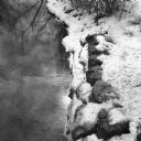
| Date: | 03 2014 |
|---|---|
| Description: | View looking down at the bank of the Yahara River. The sun is being reflected in the water near the snow covered stones on the shoreline. |
If you didn't find the material you searched for, our Library Reference Staff can help.
Call our reference desk at 608-264-6535 or email us at: