Filter: Categories of Wisconsin Historical Images
Filter: Subject of Rivers
Filter: County of Dane
Filter: Categories of Wisconsin Historical Images
Filter: Subject of Rivers
Filter: County of Dane

| Date: | 1911 |
|---|---|
| Description: | A map of the village of Black Earth and Verona. |

| Date: | 05 01 1909 |
|---|---|
| Description: | A panoramic view of the city of Stoughton. |

| Date: | 1931 |
|---|---|
| Description: | A map of the village of Verona, Wisconsin. |

| Date: | 07 12 1953 |
|---|---|
| Description: | George Karls of Waunakee is shown fishing in Cross Plains creek. |

| Date: | 07 29 1953 |
|---|---|
| Description: | Six members of Madison's Four Lakes Yacht Club are shown in a boat. In the back row, left to right, are Tom McKee, Ralph Gregg, and Sherman Olson. In the f... |

| Date: | 07 26 1953 |
|---|---|
| Description: | Boats of the Four Lakes Yacht Club at anchor in the Yahara River. There is a bridge in the background. |

| Date: | 07 26 1953 |
|---|---|
| Description: | Four Lakes Yacht Club member Clair Puttkamer is shown with his boat on a hoist operated by the Four Lakes Yacht Club on the Yahara river. The hoist facilit... |

| Date: | 07 26 1953 |
|---|---|
| Description: | The club house of the Four Lakes Yacht Club, situated along the Yahara River with boats tied up along the slips. |

| Date: | 07 26 1953 |
|---|---|
| Description: | 18 members of the more than 100 member Four Lakes Yacht Club are pictured at a club gathering. |

| Date: | 1957 |
|---|---|
| Description: | Color postcard of Dream River, North Cave, opened in 1957, in the Cave of the Mounds. |

| Date: | 1912 |
|---|---|
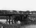
| Description: | A bridge with both a wooden walkway for pedestrians and a dirt road for automobiles. Two men and a horse are standing on the other side of the bridge. |
| Date: | 1912 |
|---|---|
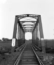
| Description: | View across a railroad bridge with metal truss system over the Sugar River. |
| Date: | 1930 |
|---|---|
| Description: | View down middle of road of car driving across a bridge over Sugar River. Another car is parked by the Wisconsin Power and Light Company. |
| Date: | 1909 |
|---|---|
| Description: | View from shoreline of wooden bridge. There are homes and barns in the distance. |
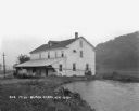
| Date: | 1925 |
|---|---|
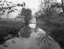
| Description: | View along shoreline of a mill on a river. There is a man loading bags onto a cart at the front. There is a wooded hill on the right. |
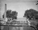
| Date: | 1895 |
|---|---|
| Description: | View from bridge towards a tall smokestack standing on the left side of the Yahara River where it is flowing out of Lake Mendota. Remnants of the foundatio... |

| Date: | 1892 |
|---|---|
| Description: | Topographical map of Madison and surrounding communities which include Lake Mendota, Lake Monona, Lake Waubesa and Lake Kegonsa. The red dots on the map sh... |
If you didn't find the material you searched for, our Library Reference Staff can help.
Call our reference desk at 608-264-6535 or email us at: