Filter: Categories of Wisconsin Historical Images
Filter: Subject of Rivers
Filter: County of Crawford
Filter: Subject of transportation
Filter: Categories of Wisconsin Historical Images
Filter: Subject of Rivers
Filter: County of Crawford
Filter: Subject of transportation

| Date: | 1905 |
|---|---|
| Description: | Elevated view of Soldiers' Grove with a bridge in the foreground. |

| Date: | 1870 |
|---|---|
| Description: | During the War of 1812, the only battle fought in Wisconsin was in Prairie du Chien, in 1814. Made fifty-six years later, this birds eye drawing depicts th... |
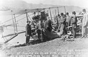
| Date: | 10 19 1911 |
|---|---|
| Description: | Pilot Hugh Robinson and his Curtiss hydroplane at Prairie du Chien during a flight that was intended to be the first all the way down the Mississippi River... |
| Date: | 1898 |
|---|---|
| Description: | Elevated view of the Kickapoo & Northern Railway locomotive and cars seen here after being derailed due to flooding on the Kickapoo River. |

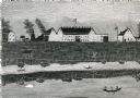
| Date: | 1908 |
|---|---|
| Description: | Elevated view of Wauzeka. A bridge over a river is in the background. |

| Date: | |
|---|---|
| Description: | 1. Stone Astor Fur Co. building built in 1808. 2. Voth Cottage, built in 1930. 3. Brisbois mansion, built 1808, by Michael Brisbois. 4. Site of Hudson Bay ... |

| Date: | 1814 |
|---|---|
| Description: | Fort Shelby, built by the Americans during the War of 1812. In 1814 the fort surrendered to British forces led by Captain Andrew W. Bulger who renamed it F... |
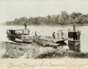
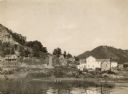
| Date: | 1895 |
|---|---|
| Description: | Prairie du Chien (vicinity) about 1895-1900. Shell buyers with their launches and barges docked at shoreline. Freshwater clam shells were used in the pearl... |

| Date: | 1878 |
|---|---|
| Description: | Illustrated map of Crawford County. On the bottom right is an inset of a group of people near a train on a railroad track. |
| Date: | |
|---|---|
| Description: | View from shoreline of a car driving over a bridge on the Kickapoo River. There is a ridge of a hill in the background. |
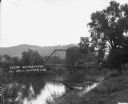
| Date: | |
|---|---|
| Description: | View down hill of a bridge across a river. There are railroad tracks going along the shoreline under the bridge. |
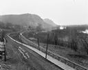
| Date: | |
|---|---|
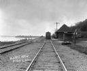
| Description: | Elevated view of a road, wooden boardwalk and railroad tracks leading towards a group of buildings near bluffs in the distance. On the right is a marshy ar... |
| Date: | |
|---|---|
| Description: | Locomotive at the De Soto depot on the Chicago, Burlington and Quincy Railroad line. The Mississippi River is on the left. |

| Date: | |
|---|---|
| Description: | View down a wooden pedestrian walkway. The Mississippi River and railroad tracks are along the shoreline on the left. Storefronts and other buildings are a... |

| Date: | 1830 |
|---|---|
| Description: | This early 19th century manuscript map of Prairie du Chien, Wisconsin, shows sections, landownership and acreages, roads, and ferries in the towns of Bridg... |

| Date: | 1911 |
|---|---|
| Description: | Blue line print. Shows post offices, houses, schools, churches, roads, routes, rivers, and railroads. Includes explanation of symbols. "H.G.M. October 12,... |

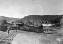
| Date: | 1926 |
|---|---|
| Description: | View from hill looking down at homes and businesses in town. A bridge goes over the Kickapoo River. The depot and railroad tracks and Main Street are behin... |

| Date: | 1890 |
|---|---|
| Description: | This is a plat map of "Wauzeeka" drawn in pencil. The map shows numbered lots, labeled streets, the Kickapoo River, and railroads. The map reads: "Laid out... |
If you didn't find the material you searched for, our Library Reference Staff can help.
Call our reference desk at 608-264-6535 or email us at: