 Filter: Categories of Wisconsin Historical Images
Filter: Subject of Rivers
Filter: County of Columbia
Filter: Year of 1800-1899
Filter: Categories of Wisconsin Historical Images
Filter: Subject of Rivers
Filter: County of Columbia
Filter: Year of 1800-1899

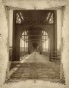
| Date: | 1831 |
|---|---|
| Description: | Drawing of Fort Winnebago (near present-day Portage) that illustrated "Wau-Bun," Juliette Kinzie's memoir of her experiences on the early Wisconsin fronti... |

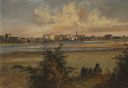
| Date: | 1868 |
|---|---|
| Description: | This 1868 birds-eye view depicts the buildings, streets, railroad, vegetation and topography of Columbus, Wisconsin. The high school, cemetery, railroad de... |

| Date: | 1870 |
|---|---|
| Description: | Bird's-eye map of Kilbourn City, now known as Wisconsin Dells. Kilbourn City was platted in the 1850s and received a boost when the La Crosse and Milwaukee... |

| Date: | 1874 |
|---|---|
| Description: | Bird's-eye map of Lodi, with inset of Public School. Includes index of churches and points of interest. |
| Date: | 1877 |
|---|---|
| Description: | View of the lower level of the Chicago, Milwaukee, and St. Paul railroad bridge at the Wisconsin Dells that would have been used by pedestrians and horse-d... |
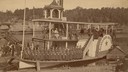
| Date: | 1888 |
|---|---|
| Description: | Members of the Kilbourn Broom Brigade on the Alexander Mitchell steamboat in the Dells. Members of the group include: Minnie Smith, Mary Sterlie, Ru... |

| Date: | 1830 |
|---|---|
| Description: | Fort Winnebago from an original drawing by Jefferson Davis. |

| Date: | 1855 |
|---|---|
| Description: | Fox-Wisconsin portage and canal map, when the canal was not yet built. From a map in the office of the city clerk at Portage. "The old trail, the location ... |

| Date: | 1831 |
|---|---|
| Description: | Fort Winnebago, a print published in Mrs. John H. Kinzie's Wau-bun (1856). |

| Date: | 1878 |
|---|---|
| Description: | View from riverbank of the Chicago Milwaukee and St. Paul railroad locomotive no. 142 on the Kilbourn bridge. |
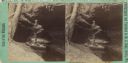
| Date: | 03 21 1881 |
|---|---|
| Description: | A man rows a small boat through Mouth Rood's Glen. Behind the boat a portable darkroom tent is set up. |
| Date: | 1856 |
|---|---|
| Description: | "After painting a number of Fox River scenes, "the artists continued their way to Fond du Lac, at the south end of Lake Winnebago, where they found some mo... |
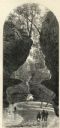
| Date: | 1874 |
|---|---|
| Description: | Engraved view of Rood's Glen. A boy plays with a toy boat at bottom left while two men and a woman talk at bottom right. Two other figures can be seen in t... |

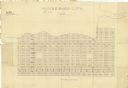
| Date: | 1861 |
|---|---|
| Description: | This 1861 map of Columbia County, Wisconsin, shows the township and range grid, towns, sections, cities and villages, railroads, roads, property owners and... |

| Date: | 1856 |
|---|---|
| Description: | This map shows plat of town, local streets, railroads, projected railroads, residential buildings, mills, and part of the Crawfish River. The map includes ... |

| Date: | 1800 |
|---|---|
| Description: | This map shows the land claim owned by the Portage Canal Company and includes an index of landownership and landmarks. The Wisconsin and Portage River, the... |
| Date: | 1830 |
|---|---|
| Description: | This plat map is pen-and-ink on tracing paper and shows a paper city planned in the late 1830's located on the shore of Swan Lake, Columbia County, Wiscons... |

| Date: | 1836 |
|---|---|
| Description: | This map shows lot and block numbers, streets, a proposed canal basin, Fort Winnebago, and the Wisconsin and Fox Rivers. Relief is shown by hachures and no... |

| Date: | 1855 |
|---|---|
| Description: | This map shows landownership, lot and block numbers, streets, a canal, bridges, Fort Winnebago, the Wisconsin River, and the Fox River. Relief is shown by ... |
If you didn't find the material you searched for, our Library Reference Staff can help.
Call our reference desk at 608-264-6535 or email us at:
