 Filter: Categories of Wisconsin Historical Images
Filter: Subject of Rivers
Filter: County of Columbia
Filter: Categories of Wisconsin Historical Images
Filter: Subject of Rivers
Filter: County of Columbia
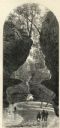
| Date: | 1874 |
|---|---|
| Description: | Engraved view of Rood's Glen. A boy plays with a toy boat at bottom left while two men and a woman talk at bottom right. Two other figures can be seen in t... |

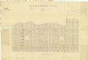
| Date: | 1861 |
|---|---|
| Description: | This 1861 map of Columbia County, Wisconsin, shows the township and range grid, towns, sections, cities and villages, railroads, roads, property owners and... |
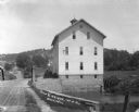
| Date: | 1911 |
|---|---|
| Description: | View across bridge of mill. There is a man standing on a wagon near the side of the mill. Behind the mill is a steep hill, with a house visible among trees... |

| Date: | 1856 |
|---|---|
| Description: | This map shows plat of town, local streets, railroads, projected railroads, residential buildings, mills, and part of the Crawfish River. The map includes ... |

| Date: | 1800 |
|---|---|
| Description: | This map shows the land claim owned by the Portage Canal Company and includes an index of landownership and landmarks. The Wisconsin and Portage River, the... |

| Date: | 1910 |
|---|---|
| Description: | Photographic postcard of an elevated view looking across the downtown area. The Crawfish River is on the left. Caption reads: "Bird's-Eye View, Columbus, W... |
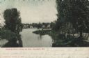
| Date: | 1910 |
|---|---|
| Description: | Color postcard view from shoreline looking towards of the dam on the Crawfish River. Buildings are on the opposite shoreline. Caption reads: "Night Scene a... |
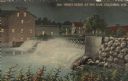
| Date: | 1900 |
|---|---|
| Description: | Color-enhanced black and white postcard looking at the dam on the Crawfish River from downstream. Caption reads: "Crawfish River, below the Dam, Columbus, ... |

| Date: | 1920 |
|---|---|
| Description: | Color postcard of the Columbus Canning Company along the river. Caption reads: "The Columbus Canning Co., Columbus, Wis." |
| Date: | 1830 |
|---|---|
| Description: | This plat map is pen-and-ink on tracing paper and shows a paper city planned in the late 1830's located on the shore of Swan Lake, Columbia County, Wiscons... |

| Date: | 1956 |
|---|---|
| Description: | This map shows Lake Wisconsin, roads, highways, parks, resort areas, camps, gardens, and Wisconsin State experimental game and fur farm. The back of the ma... |

| Date: | 1836 |
|---|---|
| Description: | This map shows lot and block numbers, streets, a proposed canal basin, Fort Winnebago, and the Wisconsin and Fox Rivers. Relief is shown by hachures and no... |

| Date: | 1855 |
|---|---|
| Description: | This map shows landownership, lot and block numbers, streets, a canal, bridges, Fort Winnebago, the Wisconsin River, and the Fox River. Relief is shown by ... |

| Date: | 1914 |
|---|---|
| Description: | This photostat map shows Fort Winnebago around 1931, land to be reserved for military purposes, roads to Fort Howard and Fort Crawford, "private property" ... |

| Date: | 1900 |
|---|---|
| Description: | This map shows landownership, churches, schools, farm houses, wagon roads, railroads, and townships and includes businesses advertisements, tables of stati... |

| Date: | 1899 |
|---|---|
| Description: | Elevated view of the navy yard near Wisconsin Dells. |

| Date: | 1900 |
|---|---|
| Description: | This manuscript map shows outline of Fort Winnebago reserve land, Fort Winnebago, claim of A. Grignon, and Indian boundaries. The Fox River and Swan Lake a... |
| Date: | 06 30 1957 |
|---|---|
| Description: | View across lawn towards a crowd, with costumed participants dressed as Native Americans, fur traders, and Jacques Marquette, at the dedication of the Marq... |

| Date: | 1941 |
|---|---|
| Description: | August Derleth posing on a boat tied up to a pier on the Wisconsin River. With him are Ruth Marshall (seated), another woman, and a dog. Four men are stand... |
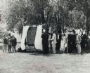
| Date: | 1935 |
|---|---|
| Description: | A flock of sheep walking along the bank of a small winding river. There are trees in the background. A typewritten note on the reverse states: "A scene in ... |
If you didn't find the material you searched for, our Library Reference Staff can help.
Call our reference desk at 608-264-6535 or email us at: