Filter: Categories of Wisconsin Historical Images
Filter: Subject of Rivers
Filter: County of Columbia
Filter: Categories of Wisconsin Historical Images
Filter: Subject of Rivers
Filter: County of Columbia
| Date: | |
|---|---|
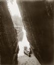
| Description: | View from Boat Cave out to the river, with two men in a canoe in the foreground. |
| Date: | |
|---|---|
| Description: | Woman and two girls on Angel Rock. There are buildings on the opposite side of the river. A bridge is in the distance. |

| Date: | |
|---|---|
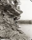
| Description: | Chimney Rock, south face. A canoe is beached on a sand bar near the foot. The river, more rock formations and trees are in the background. |
| Date: | |
|---|---|
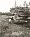
| Description: | View down sandy beach towards H.H. Bennett and Ruth Bennett on shore near Sugar Bowl. H.H. Bennett is holding a camera over his shoulder. There is an unide... |
| Date: | 09 22 1962 |
|---|---|
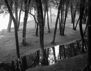
| Description: | Elevated view of trees and pool of water near the Wisconsin River in Pauquette Park. |
| Date: | 1900 |
|---|---|
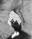
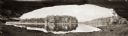
| Description: | Panoramic view of the Wisconsin River in the Wisconsin Dells from underneath an overhanging rocky outcropping. A canoe is beached on the far left. The word... |

| Date: | 1868 |
|---|---|
| Description: | This 1868 birds-eye view depicts the buildings, streets, railroad, vegetation and topography of Columbus, Wisconsin. The high school, cemetery, railroad de... |
| Date: | 1902 |
|---|---|
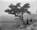
| Description: | Two women and a man pose atop Gibraltar Rock in Richmond Memorial Park, which was dedicated by Jens Jensen and the Wisconsin Friends in 1927 in order to co... |

| Date: | 1870 |
|---|---|
| Description: | Bird's-eye map of Kilbourn City, now known as Wisconsin Dells. Kilbourn City was platted in the 1850s and received a boost when the La Crosse and Milwaukee... |

| Date: | 1874 |
|---|---|
| Description: | Bird's-eye map of Lodi, with inset of Public School. Includes index of churches and points of interest. |
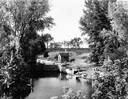
| Date: | 1877 |
|---|---|
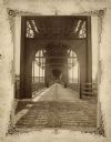
| Description: | View of the lower level of the Chicago, Milwaukee, and St. Paul railroad bridge at the Wisconsin Dells that would have been used by pedestrians and horse-d... |
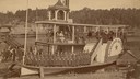
| Date: | 1888 |
|---|---|
| Description: | Members of the Kilbourn Broom Brigade on the Alexander Mitchell steamboat in the Dells. Members of the group include: Minnie Smith, Mary Sterlie, Ru... |
| Date: | 1935 |
|---|---|
| Description: | Elevated view of the Portage canal and lock, with the Indian Agency House in the center background. The canal was dug in 1849 as part of the Fox-Wisconsin ... |
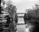
| Date: | 1909 |
|---|---|
| Description: | View from river of Dell Creek bridge with bluff and birch trees on the left. |
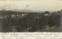
| Date: | 1900 |
|---|---|
| Description: | Elevated view from hill looking over a river towards Lodi, Wisconsin. Hills are in the distance. |

| Date: | 1830 |
|---|---|
| Description: | Fort Winnebago from an original drawing by Jefferson Davis. |

| Date: | |
|---|---|
| Description: | The first bridge over the narrows of the Wisconsin River. |

| Date: | |
|---|---|
| Description: | View of the Wisconsin River and surrounding area from Totem Tower. |
If you didn't find the material you searched for, our Library Reference Staff can help.
Call our reference desk at 608-264-6535 or email us at: