 Filter: Categories of Wisconsin Historical Images
Filter: Subject of Rivers
Filter: County of Calumet
Filter: Categories of Wisconsin Historical Images
Filter: Subject of Rivers
Filter: County of Calumet

| Date: | 1878 |
|---|---|
| Description: | Bird's-eye map of Chilton with insets of points of interest, including P.H. Becker's Brewery, Chilton House, and Gutheil's Block. |
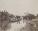
| Date: | |
|---|---|
| Description: | A man, possibly J. Schildhauer, stands at the edge of a small river with his hands on his hips. A dog is standing at the river's edge looking at a flock of... |

| Date: | 1837 |
|---|---|
| Description: | This manuscript map, copied in 1837 from a map in the Green Bay Land Office, Navarino, shows sections, the Shebowegan Trail, sandstone ledges, rivers, stre... |
| Date: | 1836 |
|---|---|
| Description: | This plat map shows the proposed Town of Whitesboro, a paper city (a city planned but never built), located on the Manitowoc River in Calumet County. Certi... |

| Date: | |
|---|---|
| Description: | Hand-colored view of the bridge and dam on the river in Chilton. Caption reads: "Bridge and Dam, Chilton, Wis." |

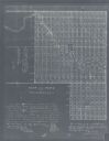
| Date: | 1990 |
|---|---|
| Description: | This map includes two insets: Plat of New Holstein village and Village of Chilton. The map also includes a table of statistics showing the assessed value o... |
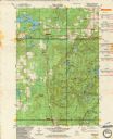
| Date: | 1982 |
|---|---|
| Description: | This standard U.S.G.S. topographic map was annotated by civil engineer and railroad historian James P. Kaysen to show the location of existing and defunct ... |
If you didn't find the material you searched for, our Library Reference Staff can help.
Call our reference desk at 608-264-6535 or email us at: