 Filter: Categories of Wisconsin Historical Images
Filter: Subject of Rivers
Filter: County of Burnett
Filter: Categories of Wisconsin Historical Images
Filter: Subject of Rivers
Filter: County of Burnett

| Date: | 1955 |
|---|---|
| Description: | This 1950s tourist brochure features a map of Burnett County, Wisconsin, and northern Polk County which shows highways and roads, railroads, landmarks, and... |

| Date: | 1991 |
|---|---|
| Description: | This 1991 map of Burnett County, Wisconsin, shows Governor Knowles State Forest, wildlife areas, public hunting grounds, and other outdoor recreation facil... |

| Date: | 1867 |
|---|---|
| Description: | This 1867 map shows the Chippewa River in northern Chippewa County, Wisconsin, from just north of Cornell to Jim Falls. Covering portions of the towns of A... |

| Date: | 1901 |
|---|---|
| Description: | Map shows lakes, rivers, schools, saw mills, post offices, creameries, and churches. Includes significant manuscript annotations showing township divisions... |
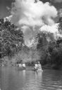
| Date: | 10 1938 |
|---|---|
| Description: | View across water towards two men in a canoe on the left, and a man and woman in a duckboat on the right paddling down the Clam River. Trees and shrubs cov... |

| Date: | 1940 |
|---|---|
| Description: | Three anglers wearing waders, including a woman on the left, are casting while standing in shallow water. The woman has a kreel on her hip, and the man on ... |
If you didn't find the material you searched for, our Library Reference Staff can help.
Call our reference desk at 608-264-6535 or email us at: