 Filter: Categories of Wisconsin Historical Images
Filter: Subject of Rivers
Filter: County of Brown
Filter: Categories of Wisconsin Historical Images
Filter: Subject of Rivers
Filter: County of Brown
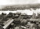
| Date: | 1889 |
|---|---|
| Description: | Elevated view of an industrial waterfront along the Fox River. |
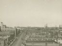
| Date: | 1920 |
|---|---|
| Description: | Elevated view of the commercial area along the east side of the Fox River. |

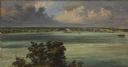
| Date: | 1889 |
|---|---|
| Description: | View of the Fox River between Green Bay and Fort Howard. |
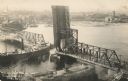
| Date: | 1910 |
|---|---|
| Description: | Elevated view of cargo ship passing under the Walnut Street Bridge on the Fox River. |
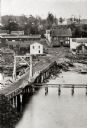
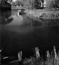
| Date: | 1865 |
|---|---|
| Description: | Elevated view of a bridge and logging debris around residential homes. |

| Date: | 1900 |
|---|---|
| Description: | View across Fox River towards the St. Norbert's College campus. |
| Date: | 1963 |
|---|---|
| Description: | View from shoreline of a boat on Suamico River. |

| Date: | 1821 |
|---|---|
| Description: | Plan of the settlement of Green Bay. |

| Date: | |
|---|---|
| Description: | This map surveyed under the direction of Capt. Thomas J. Cram is one in a series of seven. The map shows part of the Fox River and the beginning of the tow... |
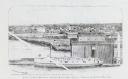
| Date: | 1876 |
|---|---|
| Description: | Drawing of a ship being loaded by Elmore & Kelly's Elevator on Fort Howard River looking north. A town and a train are in the background. |
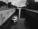
| Date: | 08 04 1962 |
|---|---|
| Description: | A boat in the Fox River Canal, headed up river. This particular lock, the Ripide Croche Lock, is located just north of Wrightstown. |
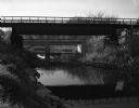
| Date: | 10 13 1963 |
|---|---|
| Description: | View from river bank of a railroad and a highway bridge crossing the Suamico River. |

| Date: | |
|---|---|
| Description: | View towards far shoreline of dam on the Fox River at De Pere. |

| Date: | 1957 |
|---|---|
| Description: | Large Letter style postcard for Green Bay depicting various scenes in the letters that spell the name of the city. Caption reads: "Greetings from Green Bay... |

| Date: | 1835 |
|---|---|
| Description: | Ink on tracing paper map of Green Bay, Wisconsin and nearby areas, Lake Winnebago, Fox and Wolf Rivers, and the junctions of the Mississippi and Wisconsin ... |
| Date: | 1856 |
|---|---|
| Description: | ". . . At De Pere they stopped on the west shore for a broad sketch of the dwellings clustered on both sides of the river. The distant dam, the mills, ware... |
| Date: | |
|---|---|
| Description: | Memohead of the Johnson Fish Company of Green Bay, Wisconsin, wholesalers of "fresh. salt. & smoked fish, oysters and live crawfish," with a fish being pul... |

| Date: | 1816 |
|---|---|
| Description: | This is a photostat copy of a manuscript map in the National Archives showing a plan of Fort Howard and a view of its north side. Originally surveyed by Wi... |

| Date: | 1914 |
|---|---|
| Description: | This map is a photostat copy from the original 1829 map in the War Department. The map shows location of Fort Howard, lots, land claims of Jacques Porlier ... |
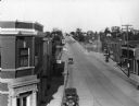
| Date: | 1930 |
|---|---|
| Description: | Elevated view of High Street (Highway 96) and the bridge over the Fox River at Wrightstown. Farmers & Traders Bank is at left, a sign for Meuleman's Elect... |
If you didn't find the material you searched for, our Library Reference Staff can help.
Call our reference desk at 608-264-6535 or email us at: