 Filter: Categories of Wisconsin Historical Images
Filter: Subject of Rivers
Filter: County of Brown
Filter: Categories of Wisconsin Historical Images
Filter: Subject of Rivers
Filter: County of Brown

| Date: | 1961 |
|---|---|
| Description: | This map shows established harbor lines, local streets, railroads, U.S. government channel, and part of Fox River. The map includes a table of reference po... |

| Date: | 1987 |
|---|---|
| Description: | This map pictorially shows local roads, local businesses with phone numbers, and parts of Fox River and bay of Green Bay. |

| Date: | 1951 |
|---|---|
| Description: | This map has depths shown by bathymetric tints and soundings and relief shown by contours, the depths are shown in feet. There is an inset map of Green Bay... |

| Date: | 1800 |
|---|---|
| Description: | This map shows plat of the town, local streets, plank roads, and part of the Fox River. The bottom of the map includes annotations, probably in pencil. |

| Date: | 1914 |
|---|---|
| Description: | This map has relief shown by hachures and shows local streets, wards, districts, railroads, Fox River, and part of Bay of Green Bay. Wards are shown in dar... |
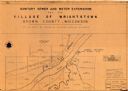
| Date: | 1961 |
|---|---|
| Description: | This map shows a sewage treatment plant site and includes an index of "Title and Index," "Watermain Details," "Sanitary Sewer Details," and "Plan B Profile... |
| Date: | 1900 |
|---|---|
| Description: | Hand-colored postcard view of Fox River dam at De Pere. Men are walking along the bridge on the left. Caption reads: "'The Dam at De Pere,' South of Green ... |

| Date: | 1874 |
|---|---|
| Description: | This map shows streets, buildings, railroads, the Fox River, the East River, and part of Green Bay. |

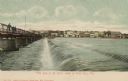
| Date: | 1905 |
|---|---|
| Description: | Elevated view of a wagon crossing the bridge over the Fox River at De Pere. Caption reads: "Greetings from De Pere, Wis." and "Bridge, Fox River." |

| Date: | 1920 |
|---|---|
| Description: | Color-enhanced postcard with an elevated view of the dam and swing bridge over the lock on the Fox River. Caption reads: "Birdseye View of Dam and Bridge o... |
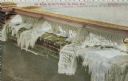
| Date: | 1910 |
|---|---|
| Description: | Elevated view of ice on dam. Caption reads: "Ice Scene on Gov't Dam, De Pere, Wis." |

| Date: | 1910 |
|---|---|
| Description: | Color enhanced view of the Fox River. Caption reads: "River Scene, De Pere, Wis." |

| Date: | 1920 |
|---|---|
| Description: | Looking at west De Pere from the east side. Shrubs and foliage are in the foreground. There are buildings and trees on the opposite shoreline. Caption read... |

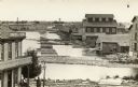
| Date: | 1875 |
|---|---|
| Description: | Handwritten note on back identifies this elevated view as the west side of Broadway from National Bank, looking south. The Fox River is in the background o... |

| Date: | 1920 |
|---|---|
| Description: | Riverview Park on Fox River, with trees and shrubs. Caption reads: "Riverview Park on Fox River, De Pere, Wis." |

| Date: | 1910 |
|---|---|
| Description: | Photographic postcard of elevated view of the Wilcox Stone Mill, and part of Broadway showing the rear view of B.F. Smith's store below the hand-drawn arro... |
| Date: | 1910 |
|---|---|
| Description: | Photographic postcard of elevated view of the back of mills lining the bridge. Coal kilns are below the hand-drawn arrow at top right. "Sawmills, gristmill... |
| Date: | 01 1935 |
|---|---|
| Description: | This map shows landownership and acreages, additions to Green Bay, roads, railroads, East River, and Fox River. The bottom left of the map reads: "January ... |

| Date: | 1906 |
|---|---|
| Description: | This map shows streets, railroads, land use, public buildings, commercial businesses, and the Menominee River. Depths are shown by gradient tints and sound... |

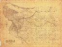
| Date: | 1888 |
|---|---|
| Description: | This is a reproduction of a map originally published in 1829 by R.W. Chandler, a pioneer settler of Galena. It is based on an earlier map by surveyor Luciu... |
If you didn't find the material you searched for, our Library Reference Staff can help.
Call our reference desk at 608-264-6535 or email us at: