 Filter: Categories of Wisconsin Historical Images
Filter: Subject of Rivers
Filter: County of Bayfield
Filter: Categories of Wisconsin Historical Images
Filter: Subject of Rivers
Filter: County of Bayfield

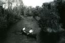
| Date: | 1966 |
|---|---|
| Description: | Gaylord Nelson participates in a canoe trip down the Namekagon River in an effort to protect the river under the National Wild and Scenic Rivers Act. |
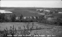
| Date: | 1935 |
|---|---|
| Description: | View from hill of Iron River winding through countryside of farms. |

| Date: | 1936 |
|---|---|
| Description: | View of two children standing in the Siskiwit River at the top of Bridge Falls. A woman stands on the shore on the right. There are trees and brush on both... |

| Date: | 1952 |
|---|---|
| Description: | This map of the northern parts of the Chequamegon Bay area in Bayfield and Ashland counties, Wisconsin, shows trails, roads, railroads, stations, the towns... |

| Date: | 1967 |
|---|---|
| Description: | This tourist brochure for Bayfield County, Wisconsin, from 1967 includes a map of the county showing towns, cities and villages, highways and roads, railro... |

| Date: | |
|---|---|
| Description: | View from water of a log rolling contest. One man is still upright and the other has fallen into the water. A boat is visible to the left and trees line th... |

| Date: | 1910 |
|---|---|
| Description: | This map is ink and pen on tracing cloth and shows plat of the town, local streets, county roads, railroads, school houses, town halls, hotels, sheds, barn... |

| Date: | 1971 |
|---|---|
| Description: | A topgraphical map of Cable, Wisconsin showing railroads. |

| Date: | 1971 |
|---|---|
| Description: | A topographical map of Namekagon Lake and the surrounding area. |

| Date: | 1935 |
|---|---|
| Description: | This topographical map of the forest preserve shows highways, roads, trails, telephone lines, Native American reservations, Ranger sub-stations, state nurs... |
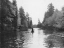
| Date: | 10 1937 |
|---|---|
| Description: | Rear view of two canoes, one directly behind the other, each propelled by a man traveling on the Brule River. The man in the foreground is using a pole, an... |

| Date: | 1971 |
|---|---|
| Description: | A topographical map of the Grand View NW quadrangle. |
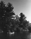
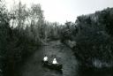
| Date: | 1959 |
|---|---|
| Description: | Paddlers in a canoe on their way down the Namekagon river. The shoreline on the left is tree-covered. |

| Date: | 1947 |
|---|---|
| Description: | Mary Griggs (Burke), wearing a patterned short-sleeve blouse, shorts, and a flower in her hair, is sitting in the front of a canoe on the Namakagon River i... |
| Date: | 1953 |
|---|---|
| Description: | Mary Griggs is sitting in the stern of a canoe paddling the Namakagon River with a male friend sitting in the bow. Mary is wearing shorts and a white blous... |
| Date: | 1954 |
|---|---|
| Description: | Mary Livingston Griggs is sitting in the bow of a canoe as a young male companion paddles them on the Namakagon River. Mary is wearing a white blouse and h... |

| Date: | 1944 |
|---|---|
| Description: | Mary Griggs is lounging in a cedar strip canoe with green canvas covering, along the shoreline of the Namakagon River. Mary has a yellow bow in her hair. |

| Date: | 1950 |
|---|---|
| Description: | Text on front reads: "Sioux River." On reverse: "Big Rock on Sioux River. Washburn, Wisconsin. A thrilling day of trout fishing and picnicking at the Big R... |
If you didn't find the material you searched for, our Library Reference Staff can help.
Call our reference desk at 608-264-6535 or email us at:
