Filter: Categories of Wisconsin Historical Images
Filter: Subject of Rivers
Filter: County of Ashland
Filter: Subject of land
Filter: Categories of Wisconsin Historical Images
Filter: Subject of Rivers
Filter: County of Ashland
Filter: Subject of land
| Date: | |
|---|---|
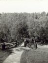
| Description: | Two people on a rustic bridge over Bad River at Copper Falls State Park. |
| Date: | 1885 |
|---|---|
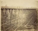
| Description: | Elevated view of the Wiscsonsin Central's bridge over the White River, about six miles south of Ashland. The bridge was 1600 ft. long and 110 ft. above the... |
| Date: | 1910 |
|---|---|
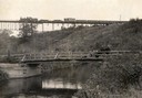
| Description: | View from shoreline of a railroad train crossing a bridge over the famous White River near Ashland. In the foreground is an open automobile crossing the ri... |
| Date: | 1929 |
|---|---|
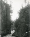
| Description: | The gorge of the Bad River below Brownstone Falls. |
| Date: | 1935 |
|---|---|
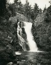
| Description: | View from rocky shoreline towards the Brownstone Falls in Copper Falls State Park. |
| Date: | 1935 |
|---|---|
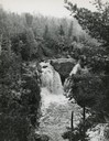
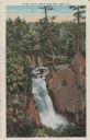
| Description: | Elevated view of the Brownstone Falls on the Bad River. |
| Date: | 1937 |
|---|---|
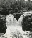
| Description: | Elevated view of the waterfall where the Bad River tumbles over the Keweenawan Trap Ledge. |
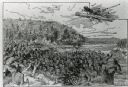
| Date: | |
|---|---|
| Description: | An illustration titled "The Battle of the Brule" based on an 1840's battle between the Ojibwe and Dakota Sioux over territory in the Ashland, Wisconsin are... |
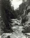
| Date: | |
|---|---|
| Description: | View up the Bad River Gorge below Copper Falls at Copper Falls State Park. |
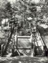
| Date: | 1940 |
|---|---|
| Description: | Two rustic stairways leading down to the Bad River at Copper Falls State Park. At the bottom of the stairs is a sign telling the geological story of Copper... |

| Date: | 07 1940 |
|---|---|
| Description: | Two boys and two girls swimming at the Bad River at Copper Falls State Park. One of the girls is diving off the dock that also has a platform. In the backg... |

| Date: | 1935 |
|---|---|
| Description: | View of Bad River rushing over cliff at Copper Falls State Park. |
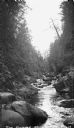
| Date: | 1935 |
|---|---|
| Description: | The Bad River flowing through boulders and a gorge. |
| Date: | |
|---|---|
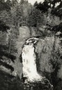
| Description: | View of water streaming down the rock and tree-lined Tyler Falls. A white walk bridge is in the background. |

| Date: | 1939 |
|---|---|
| Description: | This map shows the towns to Gingles, Sanborn, and Guney as well as Chequamegon Bay, Kakagon River, White River, Marengo River, Bad River, Potato River, Vau... |

| Date: | 1952 |
|---|---|
| Description: | This 1952 map shows the trails, roads, and railroads through the counties of Ashland, Bayfield, Sawyer, Price, Iron, and Vilas. Also shown are lakes, river... |

| Date: | 1896 |
|---|---|
| Description: | This 1896 map shows the township and range system, sections, cities and villages, railroads, roads, vacant land and land sold by the Wisconsin Central Rail... |

| Date: | 1896 |
|---|---|
| Description: | This 1898 map shows the township and range system, sections, cities and villages, railroads, roads, vacant land and land sold by the Wisconsin Central Rail... |

| Date: | 1949 |
|---|---|
| Description: | This 1949 map shows the topography and significant landmarks in Copper Falls State Park, Ashland County, Wisconsin. |
If you didn't find the material you searched for, our Library Reference Staff can help.
Call our reference desk at 608-264-6535 or email us at: