 Filter: Categories of Wisconsin Historical Images
Filter: Subject of Rivers
Filter: Community of Wauzeka
Filter: Categories of Wisconsin Historical Images
Filter: Subject of Rivers
Filter: Community of Wauzeka
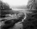
| Date: | 08 13 1961 |
|---|---|
| Description: | A Wisconsin River swamp. The swampy area is framed by trees with more trees in the background hidden by fog. |

| Date: | 1908 |
|---|---|
| Description: | Elevated view of Wauzeka. A bridge over a river is in the background. |

| Date: | 08 20 1961 |
|---|---|
| Description: | A tree-lined view of the Wisconsin River. The photograph was taken from an elevated area near a highway. |

| Date: | 1890 |
|---|---|
| Description: | This is a plat map of "Wauzeeka" drawn in pencil. The map shows numbered lots, labeled streets, the Kickapoo River, and railroads. The map reads: "Laid out... |

| Date: | 1856 |
|---|---|
| Description: | This map shows lot and block numbers, streets, a mill, the Milwaukee and Mississippi Railroad, the train depot, and the Kickapoo River. Included in the low... |

| Date: | 1856 |
|---|---|
| Description: | This map is ink and color on paper and mounted on cloth. The map shows lot and block numbers, streets, a railroad, and the Kickapoo River. Some lots are c... |

| Date: | 1910 |
|---|---|
| Description: | Text on front reads: "Kickapoo River Scene, Wauzeka, Wis." Elevated view of the shore of the Kickapoo River, with boats, piers and boathouses. A man in a r... |
If you didn't find the material you searched for, our Library Reference Staff can help.
Call our reference desk at 608-264-6535 or email us at: