 Filter: Categories of Wisconsin Historical Images
Filter: Subject of Rivers
Filter: Community of Platteville
Filter: Categories of Wisconsin Historical Images
Filter: Subject of Rivers
Filter: Community of Platteville

| Date: | 1875 |
|---|---|
| Description: | Bird's-eye map of Platteville. |
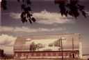
| Date: | 07 1949 |
|---|---|
| Description: | Gothic roofed barn with river scene painted on its roof by Frank Engebretson. |

| Date: | 1969 |
|---|---|
| Description: | This street map was given out by Mound City Bank and features a legend of points of interest and a street index. Streets are labeled as is the Roundtree Br... |

| Date: | 1960 |
|---|---|
| Description: | This street map was likely given out by Mound City Bank and features a legend of points of interest and a street index. Streets are labeled as is the Round... |

| Date: | 1906 |
|---|---|
| Description: | This topographical map shows the Little Platte River, shafts, test-pits, old workings, contour lines of Galena limestone elevation, railroads, and building... |
If you didn't find the material you searched for, our Library Reference Staff can help.
Call our reference desk at 608-264-6535 or email us at: