 Filter: Categories of Wisconsin Historical Images
Filter: Subject of Rivers
Filter: Community of New Orleans
Filter: Categories of Wisconsin Historical Images
Filter: Subject of Rivers
Filter: Community of New Orleans
| Date: | |
|---|---|
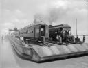
| Description: | View of Southern Pacific Railroad cars being transferred across the Mississippi River with a barge near New Orleans. |
| Date: | |
|---|---|
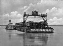
| Description: | View of a barge transporting railroad cars and an engine across a river. Several men are on the barge, including one on an overhead structure. Text on phot... |
| Date: | |
|---|---|
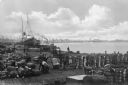
| Description: | Elevated view of a dock scene, where workers are preparing bales of cotton for loading. A steamship and a tugboat are nearby. More ships and the shoreline ... |

| Date: | |
|---|---|
| Description: | View of railroad cars being ferried across the river. |

| Date: | 1759 |
|---|---|
| Description: | Map of New Orleans at the start of the French & Indian War, including two inset maps entitled "The Course of the Mississipi River from Bayagoulas to the Se... |

| Date: | 1769 |
|---|---|
| Description: | Map of New Orleans at the start of the French & Indian War, including two inset maps of the Mississippi River Delta and Fort la Balise. It shows streets, r... |

| Date: | 1761 |
|---|---|
| Description: | Map of New Orleans with north oriented towards the upper right corner. It shows the land around the city, the Mississippi River, anchorages, roads leading ... |
If you didn't find the material you searched for, our Library Reference Staff can help.
Call our reference desk at 608-264-6535 or email us at: