 Filter: Categories of Wisconsin Historical Images
Filter: Subject of Rivers
Filter: Community of Neenah
Filter: Categories of Wisconsin Historical Images
Filter: Subject of Rivers
Filter: Community of Neenah
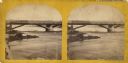
| Date: | 1870 |
|---|---|
| Description: | Stereograph view of Cedar Street Bridge(?) with a rocky shoreline on the left. The construction of this bridge is the same as the Cedar Street bridge, but ... |
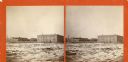
| Date: | 1870 |
|---|---|
| Description: | Stereograph view across what may be the Fox River, or a field with snow on the ground. There are large buildings behind a fence in the background. Caption ... |
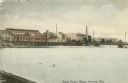
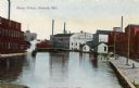
| Date: | 1910 |
|---|---|
| Description: | View of the Fox River with power plants and paper mills. Caption reads: "Water Power Plants, Neenah, Wis." |
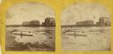
| Date: | 1870 |
|---|---|
| Description: | Stereograph view of the flour mill district. The Cedar Street Bridge is in the background, and the mills are, right to left going back, the Winnebago Flour... |

| Date: | 1870 |
|---|---|
| Description: | Stereograph of flour mill district. The Walnut Street bridge is in the background and the mill to the right is the Atlantic Mills (Neenah Stone Mills in 18... |
| Date: | 1910 |
|---|---|
| Description: | Industrial area with view of Kimberly Clark Mill, and other unidentified mills. Caption reads: "Water Power, Neenah, Wis." |
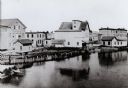
| Date: | |
|---|---|
| Description: | View across water towards buildings along the shoreline. The building on the left has a sign that reads: "Neenah Mills". |

| Date: | 06 1875 |
|---|---|
| Description: | These manuscript drawings show the profile of the Neenah Dam, between Lake Winnebago and Little Lake Butte des Morts on the Fox River in Winnebago County, ... |

| Date: | 1936 |
|---|---|
| Description: | This map of Neenah and Menasha shows some parks, churches, convention halls, and other buildings. These points of interest are in red ink. Streets, Little ... |

| Date: | 1903 |
|---|---|
| Description: | This maps shows what may be Ho Chunk Native American burial mounds. Also noted on the map is the Fox River, the Doty homestead, stockade embankment, the We... |

| Date: | 1846 |
|---|---|
| Description: | This plat map, which features the very early spelling of Wisconsin as "Wiskonsin", was created sometime between 1846 and 1854 and shows a canal and dam on ... |

| Date: | 1840 |
|---|---|
| Description: | This map shows a line of proposed construction for defending the north side of the canal against inundation from the Wisconsin River and location of Fort W... |

| Date: | 1900 |
|---|---|
| Description: | A giant specimen of Ulmus americana, captioned "Old Council Tree," standing along the Fox river. Houses are along the far shoreline; a wooden fence ... |
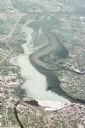
| Date: | 05 18 1970 |
|---|---|
| Description: | Aerial view titled "Neenah Pollution." The view is looking north from over Neenah at Little Lake Butte des Morts which is discolored. |
If you didn't find the material you searched for, our Library Reference Staff can help.
Call our reference desk at 608-264-6535 or email us at: