Filter: Categories of Wisconsin Historical Images
Filter: Subject of Rivers
Filter: Community of Mauston
Filter: Categories of Wisconsin Historical Images
Filter: Subject of Rivers
Filter: Community of Mauston

| Date: | 03 16 1949 |
|---|---|
| Description: | Aerial view of Mauston, Wisconsin. |

| Date: | 1920 |
|---|---|
| Description: | Slightly elevated view towards a man rowing his boat along the Lemonweir River. Caption reads: "Scene on Lemonweir River — Oak & Maple Grove Resort — Maust... |

| Date: | |
|---|---|
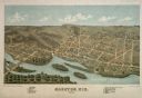
| Description: | This plat map shows numbered blocks and lots, local streets, the La Crosse and Milwaukee Railroad, and part of the Lemonwier [i.e. Lemonweir] River. |

| Date: | 1958 |
|---|---|
| Description: | This blue line print map shows lot and block numbers and dimensions, additions, and some landownership. The Lawrence River is labeled. |

| Date: | |
|---|---|
| Description: | View down river towards a man in a rowboat. Caption reads: "Scene on Lemonweir River, Mauston, Wis." |

| Date: | |
|---|---|
| Description: | View across water towards the bluff on the river. Caption reads: "Castle Rock on Wisconsin River, Mauston, Wis." |
If you didn't find the material you searched for, our Library Reference Staff can help.
Call our reference desk at 608-264-6535 or email us at: