Filter: Categories of Wisconsin Historical Images
Filter: Subject of Rivers
Filter: Community of Madison
Filter: Categories of Wisconsin Historical Images
Filter: Subject of Rivers
Filter: Community of Madison
| Date: | |
|---|---|
| Description: | The Spillway on Lake Mendota (Tenney Park) and the Yahara River. |

| Date: | 1930 |
|---|---|
| Description: | Aerial view of Tenney Park, including the lagoon, residences surrounding the park, and the shoreline of Lake Mendota on bottom left. |
| Date: | |
|---|---|
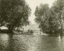
| Description: | Farwell's Mill on the Yahara River at Lake Mendota. |

| Date: | 1853 |
|---|---|
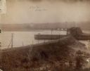
| Description: | Farwell's Mill on the Yahara River at Lake Mendota. |

| Date: | 1907 |
|---|---|
| Description: | The Yahara River Parkway, with the old Lapham School at 1436 East Dayton Street at North Thornton visible on the righthand side. |

| Date: | 1906 |
|---|---|
| Description: | View from shoreline looking over a pathway towards the Steensland Bridge and Yahara River Parkway at East Washington Avenue. |
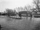
| Date: | 02 23 1953 |
|---|---|
| Description: | University of Wisconsin varsity crew in a practice boat on the Yahara River. View looking south with Westinghouse Electric Supply Company, 110 North Thorn... |
| Date: | 02 23 1953 |
|---|---|
| Description: | University of Wisconsin crew rowing down the Yahara River. View looking south toward railroad bridge in the 100 block of North Thornton Avenue. |
| Date: | 02 23 1953 |
|---|---|
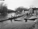
| Description: | University of Wisconsin crew gets into their shell from the dock on the Yahara River with Trachte boat houses in the background. View looking northwest tow... |

| Date: | 07 05 1975 |
|---|---|
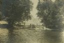
| Description: | The Tenney Park Bridge over the Yahara River. |

| Date: | 1890 |
|---|---|
| Description: | Left half of a plat map of the "East Part of the city of Madison". |

| Date: | 1855 |
|---|---|
| Description: | Map of the city of Madison, Dane County, published by George Harrison, surveyed and drawn by P. McCabe, and engraved by J.H. Colton & Co., New York. In add... |

| Date: | 1948 |
|---|---|
| Description: | Two preliminary watercolors of the right panel of the Centennial Mural in the Wisconsin Historical Society. The panel displays the history of Wisconsin ex... |

| Date: | 1948 |
|---|---|
| Description: | A watercolor of the right panel of the Centennial Mural in the Wisconsin Historical Society. This panel displays the history of Wisconsin exploration, mos... |

| Date: | 1910 |
|---|---|
| Description: | Scale: 1:62500. Topography by Robert Muldrow. Surveyed in 1904. Edition of Aug. 1906, reprinted in 1910. |

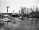
| Date: | 06 18 1945 |
|---|---|
| Description: | Four people fishing from the Westport bridge. Six people have lost their lives within the past eight weeks at this bridge. |
If you didn't find the material you searched for, our Library Reference Staff can help.
Call our reference desk at 608-264-6535 or email us at: