 Filter: Categories of Wisconsin Historical Images
Filter: Subject of Rivers
Filter: Community of Kenosha
Filter: Categories of Wisconsin Historical Images
Filter: Subject of Rivers
Filter: Community of Kenosha
| Date: | |
|---|---|
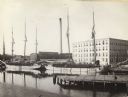
| Description: | The buildings of Allen & Sons Tannery, with boats carrying supplies in the foreground. |

| Date: | 10 19 1836 |
|---|---|
| Description: | This 1836 manuscript map shows the sections, windfalls, marshes, streams, prairies, acreages, and former mouth of the Pike River in what is now the eastern... |

| Date: | 1910 |
|---|---|
| Description: | This map is a survey of Kenosha Harbor and shows local streets, public buildings, local businesses, and part of Lake Michigan. Included is text on sailing ... |

| Date: | 1954 |
|---|---|
| Description: | This photocopy map shows a early sketch of the settlement Southport. Rivers, lakes, other settlements, county boundaries, and roads are labeled. A portion ... |
If you didn't find the material you searched for, our Library Reference Staff can help.
Call our reference desk at 608-264-6535 or email us at:
