Filter: Categories of Wisconsin Historical Images
Filter: Subject of Rivers
Filter: Community of Janesville
Filter: Categories of Wisconsin Historical Images
Filter: Subject of Rivers
Filter: Community of Janesville

| Date: | 1877 |
|---|---|
| Description: | Bird's-eye map of Janesville on the Rock River. |

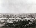
| Date: | 1860 |
|---|---|
| Description: | Bird's-eye view of Janesville from the High School building. |
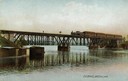
| Date: | |
|---|---|
| Description: | The railroad bridge over the Rock River. |
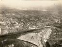
| Date: | 1934 |
|---|---|
| Description: | Aerial view of Janesville showing the river fill for the new sewerage disposal plant. |
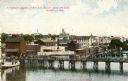
| Date: | 1905 |
|---|---|
| Description: | The Fourth Avenue bridge above the dam. Caption reads: "Steamboat Landing at 4th Ave. Bridge Above the Dam, Janesville, Wis." |

| Date: | 1905 |
|---|---|
| Description: | View across the dam in Janesville. Caption reads: "The Dam, Janesville, Wis." |

| Date: | 1870 |
|---|---|
| Description: | Elevated view over river of Dodge Street in Janesville looking west. |

| Date: | 1865 |
|---|---|
| Description: | Milwaukee Street looking west. In the foreground is a dog standing on a bridge. Signs on a building on the right read: "Furniture" and "Valley Chief Reaper... |
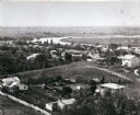
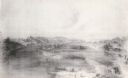
| Date: | 1860 |
|---|---|
| Description: | Elevated view of the Janesville Countryside. |
| Date: | 1893 |
|---|---|
| Description: | View from the south, with a railroad in the foreground, a river in the middle distance, and Janesville in the background. |
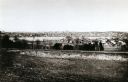
| Date: | 1860 |
|---|---|
| Description: | Elevated view of Janesville with a residential area in the foreground and the business district in the background. |

| Date: | |
|---|---|
| Description: | View across river and bridges towards Janesville. Caption reads: "Greetings from Janesville, Wis., U. S. A." Text at bottom reads: "Panorama." |

| Date: | 1865 |
|---|---|
| Description: | Elevated view of Milwaukee Street. |

| Date: | 1919 |
|---|---|
| Description: | Elevated view of the Rock River, with a large smokestack and water tower on the left. Richard Lloyd Jones was born in Janesville in 1873 and lived there u... |

| Date: | |
|---|---|
| Description: | An ink and water color on paper, hand-drawn map showing the section divisions in the southern half of the Janesville Township (Township 3 North, Range 12 E... |

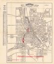
| Date: | 1860 |
|---|---|
| Description: | Map showing a plat of the city, land ownership by name, wards by number, local streets, buildings, fair grounds, nurseries, and part of Rock River. The map... |
| Date: | 1924 |
|---|---|
| Description: | This map of Janesville was distrusted by the Fifield Lumber Company and features labeled streets, the Rock River, and Fifield Lumber Company buildings in r... |
If you didn't find the material you searched for, our Library Reference Staff can help.
Call our reference desk at 608-264-6535 or email us at: