 Filter: Categories of Wisconsin Historical Images
Filter: Subject of Rivers
Filter: Community of Fort Atkinson
Filter: Categories of Wisconsin Historical Images
Filter: Subject of Rivers
Filter: Community of Fort Atkinson

| Date: | 1870 |
|---|---|
| Description: | Birds eye drawing of Fort Atkinson, Jefferson County, depicts street names and street layouts, houses, trees, Rock River and Bark River. A reference key at... |

| Date: | 1893 |
|---|---|
| Description: | This photocopy of a bird’s-eye-view map shows illustrated houses and various buildings. Streets and the Rock River are labeled. An index to points of inter... |
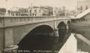
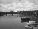
| Date: | 1910 |
|---|---|
| Description: | View of a river and Main Street bridge above the river. Commercial buildings line the street on the opposite side of the bridge. Caption reads: "Main St. B... |
| Date: | 1910 |
|---|---|
| Description: | Elevated view of the Northwestern Manufacturing Company plant. Caption reads: "Birds-eye View showing Northwestern Mfg. Co.'s Plant, Fort Atkinson, Wis." |
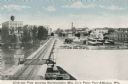
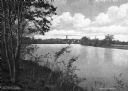
| Date: | 1915 |
|---|---|
| Description: | View across water towards the Main Street Bridge over the Rock River. |
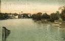
| Date: | 1909 |
|---|---|
| Description: | View of the Rock River, with boathouses along the right shoreline, and buildings in the distance on the left at a bend in the river. Pilings are in the for... |
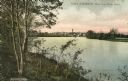
| Date: | 1915 |
|---|---|
| Description: | Distant view of Fort Atkinson from the shoreline of the Rock River. Caption reads: "Fort Atkinson, Wis., from Rock River." |
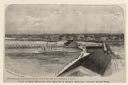
| Date: | 1876 |
|---|---|
| Description: | Elevated view of Fort Howard taken from Elmore and Kelly's Elevator with the dam and river. A tugboat is in the river above the dam. Caption reads: "View o... |
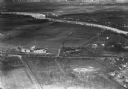
| Date: | 1934 |
|---|---|
| Description: | Aerial view of the Jones dairy farm, Fort Atkinson, in winter. The Rock River is in the background. |
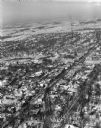
| Date: | 01 22 1949 |
|---|---|
| Description: | Aerial photograph of the city of Fort Atkinson. |

| Date: | 07 21 1962 |
|---|---|
| Description: | A parking lot underneath a newly developed block of stores. The Rock River is visible just beyond the parking lot. There is a bridge in the background. |
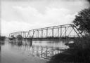
| Date: | |
|---|---|
| Description: | View from shoreline toward an unidentified railroad bridge spanning a river. |

| Date: | |
|---|---|
| Description: | View over tree-tops toward a man rowing a boat beneath a partially covered bridge spanning the Rock River. Factories, industrial buildings, and Saint Paul'... |
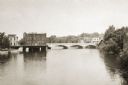
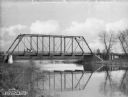
| Date: | |
|---|---|
| Description: | Elevated view looking west from the Main Street Bridge, a partially covered wooden bridge spanning the Rock River. In the foreground on the right are boats... |
| Date: | |
|---|---|
| Description: | View from the left side riverbank of the Bark River, whose water is reflecting the bridge above. A man is driving an automobile over the bridge toward the ... |
| Date: | |
|---|---|
| Description: | View from hill on left side riverbank of the Rock River. In the distance is a bridge, water tower, and Saint Paul's Lutheran Church. |

| Date: | |
|---|---|
| Description: | View of a wooden bridge spanning the Bark River. Probably late fall or early spring as the trees are leafless. Caption reads: "Bark River Bridge, Fort Atki... |

| Date: | 09 1884 |
|---|---|
| Description: | Sanborn map of Fort Atkinson including Barrie, Germany, and North Water Streets. |

| Date: | 09 1884 |
|---|---|
| Description: | Sanborn map of Fort Atkinson including South Water and Milwaukee Streets. |

| Date: | 1870 |
|---|---|
| Description: | Bird’s-eye view map. "Looking north east." Indexed for points of interest. Shows homes, businesses, and the Bark and Rock River. Streets running west to ea... |
If you didn't find the material you searched for, our Library Reference Staff can help.
Call our reference desk at 608-264-6535 or email us at: