 Filter: Categories of Wisconsin Historical Images
Filter: Subject of Rivers
Filter: Community of Black River Falls
Filter: Categories of Wisconsin Historical Images
Filter: Subject of Rivers
Filter: Community of Black River Falls

| Date: | 1910 |
|---|---|
| Description: | Outdoor view from shoreline towards a powerhouse on the river, with town buildings in the background on the opposite shoreline. Identified as the second po... |

| Date: | 1910 |
|---|---|
| Description: | Outdoor view looking down a hill towards a powerhouse on the river, with town buildings on a hill in the background. Identified as the second powerhouse th... |

| Date: | 1910 |
|---|---|
| Description: | Outdoor view looking down at a powerhouse on the river, with town buildings in the background. Identified as the second powerhouse that was replaced in 191... |

| Date: | 1910 |
|---|---|
| Description: | Outdoor view looking down at a powerhouse, with town buildings in the background and men fishing along the shoreline. Identified as the third powerhouse bu... |

| Date: | 1905 |
|---|---|
| Description: | View across water towards a powerhouse among very high water on the Black River. Identified as the second power house with high water in 1905. |

| Date: | |
|---|---|
| Description: | View across river just below the dam towards buildings on the opposite shoreline. The buildings identified include the Spaulding wagon shop on the left, an... |

| Date: | |
|---|---|
| Description: | View from side of bridge towards a horse pulling a woman in a buggy across the bridge. The river can be seen on the left and right below the bridge. An unp... |

| Date: | 1907 |
|---|---|
| Description: | Elevated view across rushing water towards a construction site of a dam on a river. Identified as the construction of the Hatfield Dam, looking northwest. |

| Date: | |
|---|---|
| Description: | View of a river with a log jam, and a bridge in the distance. Identified as the Hatfield wagon bridge over the Black River, reportedly built in 1899, destr... |

| Date: | |
|---|---|
| Description: | Elevated view of town. Identified as probably the city of Black River Falls from the Jackson County Courthouse, and looking northeast. |

| Date: | |
|---|---|
| Description: | Elevated view from hill towards a grove of trees in high water. Location identified as Bright's Grove. |

| Date: | 1911 |
|---|---|
| Description: | View from bridge across river towards a town along the shoreline. Location identified as showing German Hill and showing North Water Street before 1911. |

| Date: | 1922 |
|---|---|
| Description: | View along steep shoreline towards people among the rubble near buildings at the top of the bank on the left. The river is on the right. Location identifie... |

| Date: | |
|---|---|
| Description: | Elevated view of a construction site. There are two men standing on a dirt road, looking down at other men down below them working around a brick wall. A w... |

| Date: | 1911 |
|---|---|
| Description: | Outdoor view of a construction site, with wreckage in a ditch. Location identified as the fill and reconstruction of Town Creek after the 1911 flood in Bla... |

| Date: | 1911 |
|---|---|
| Description: | View towards a construction site, with people walking on a dirt road, and others working at the site. Location identified as the reconstruction following t... |

| Date: | |
|---|---|
| Description: | View of a railway at a construction site, with wreckage on the left side and a bridge in the background. Identified as the fill and reconstruction of Town ... |
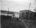
| Date: | 10 1911 |
|---|---|
| Description: | View towards river with high water flooding over several buildings behind a group of people in the foreground. Identified as the flood of the Black River i... |

| Date: | |
|---|---|
| Description: | View across water towards a brick building behind a group of trees along the shoreline. Identified as the York iron mine and boarding house. |

| Date: | |
|---|---|
| Description: | Elevated view of a body of water with frost on the banks. Identified as the Black River. Logs are along the shore. |
If you didn't find the material you searched for, our Library Reference Staff can help.
Call our reference desk at 608-264-6535 or email us at: