 Filter: Categories of Wisconsin Historical Images
Filter: Subject of Rivers
Filter: Community of Baraboo
Filter: Categories of Wisconsin Historical Images
Filter: Subject of Rivers
Filter: Community of Baraboo
| Date: | |
|---|---|
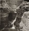
| Description: | Elevated view of dam at Pewit's Nest on Skillet Creek. |
| Date: | |
|---|---|
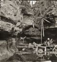
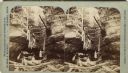
| Description: | Man and woman sitting on logs near the water line at Pewit's Nest. Wooden debris on ground and attached to rock face. A small waterfall is in background. |

| Date: | 1870 |
|---|---|
| Description: | Baraboo was first settled around 1838, and by 1870 it had become the county seat and the thriving village illustrated here. This birds eye drawing depicts ... |

| Date: | 1886 |
|---|---|
| Description: | Bird's-eye map of Baraboo with inset of Devil's Lake, the south and east sides of the commercial square, the First National Bank, and the Warren House hote... |
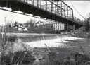
| Date: | |
|---|---|
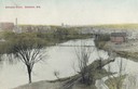
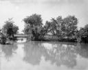
| Description: | Elevated view of the Baraboo River towards a bridge, water tower, and the town beyond. Caption reads: "Baraboo River, Baraboo, Wis." |

| Date: | 1955 |
|---|---|
| Description: | Aerial view of town, with the Baraboo River. |
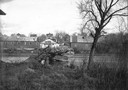
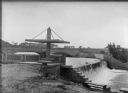
| Date: | 1914 |
|---|---|
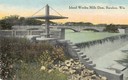
| Description: | Slightly elevated view of the dam, with a bridge in the background. Caption reads: "Island Wollen Mills Dam, Baraboo, Wis." |
| Date: | 1918 |
|---|---|
| Description: | View of the Ringling Brothers Circus winter quarters from across the Baraboo River, looking due north. The brick building, center, was one of the two "Cat ... |
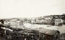
| Date: | 1918 |
|---|---|
| Description: | View of waterfall, bridge, Baraboo river, and town from the riverbank. |
| Date: | 1868 |
|---|---|
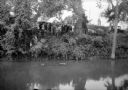
| Description: | View of the Baraboo River and surrounding structures. |

| Date: | 1950 |
|---|---|
| Description: | Map showing buildings formerly used as Ringling Brothers Circus winter quarters, along with adjoining buildings. |
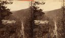
| Date: | |
|---|---|
| Description: | A view of a valley possibly in or around Devil's Lake. A man is visible in the foreground, hiking up the steep incline of the valley. |
| Date: | |
|---|---|
| Description: | Two women and a man boat through a narrow passageway amidst large rock formations. Wooden debris from an unknown cause blocks their passage. This may be Pe... |
| Date: | 1925 |
|---|---|
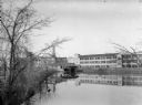
| Description: | View across river of a large mill or factory complex, possibly the Island Woolen Mill. In front of the mill is a roofed boathouse, with a canoe hanging fro... |
| Date: | 1930 |
|---|---|
| Description: | View across river of a crowd gathered on a steep riverbank overlooking a submerged car. There is a large house at the top of the hill. |
| Date: | 1930 |
|---|---|
| Description: | A view of high water on a river, possibly the Baraboo River, in a rural setting. |
| Date: | 1925 |
|---|---|
| Description: | The Island Woolen Mill dam and bridge over the Baraboo River. In the foreground is a concrete "pergola" which shades a small bench. Molded into a concrete ... |

| Date: | 1925 |
|---|---|
| Description: | Two large clay block silos stand beside a river. There is a large building, possibly a mill, behind the silos, a barn to the right and a shed on the left. ... |

| Date: | |
|---|---|
| Description: | Entrance to Cold Water Canyon near Wisconsin Dells. In the foreground is a wooden walkway across the water. |

| Date: | |
|---|---|
| Description: | Map of Baraboo and its surroundings, showing the ancient mound city, the water power, and thoroughfares, drawn by William H. Canfield. Canfield includes sk... |
If you didn't find the material you searched for, our Library Reference Staff can help.
Call our reference desk at 608-264-6535 or email us at: